Beato António night lights from space
Night Light of Beato António (Lisbon) from space (Portugal) Src. Average luminocity for 10x10km area is 65.6293% and for 50x50km: 51.9178%.
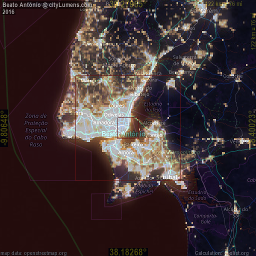
Analysis of Beato António night lights 2016
Square area 10x10 km:
 36.39%
90-99
8.16%80-89
0.68%70-79
1.7%60-69
4.93%50-59
7.14%40-49
8.16%30-39
9.35%20-29
20.41%10-19
3.06%0-9
0%Square area 50x50 km:
15.75%90-99
12.86%80-89
5.03%70-79
5.34%60-69
6.79%50-59
5.61%40-49
5.09%30-39
6.47%20-29
8.47%10-19
7.79%0-9
20.81%Clear (daylight) street map image can be seen on geolist.org.
Map coordinates:
39° 16' 46.7" North, 9° 48' 23.3" West
38° 43' 59.8" North, 9° 6' 12.1" West
38° 10' 57.6" North, 8° 24' 0.8" West
Some cities around Beato António sort by population:
• Lisbon
3.2 km =2 mi,  234°
234°
• Olivais
4.1 km =2.5 mi,  355°
355°
• Alvalade
4.2 km =2.6 mi,  302°
302°
• Moscavide e Portela
5.1 km =3.2 mi,  1°
1°
• Sacavém
6.5 km =4 mi, 356°
• Charneca
6.6 km =4.1 mi,  328°
328°
• Prior Velho
6.7 km =4.2 mi,  346°
346°
• Cacilhas
6.6 km =4.1 mi,  217°
217°
2271001 (p: 12,737)
Sources (retrieved 2019-11-25):
» Earth at Night: Flat Maps 2012, 2016