Qaţanah night lights from space
Night Light of Qaţanah (West Bank) from space (Palestinian Territory) Src. Average luminocity for 10x10km area is 76.0385% and for 50x50km: 58.2866%.
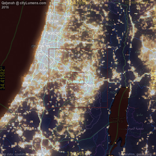
Analysis of Qaţanah night lights 2016
Square area 10x10 km:
 20.15%
90-99
18.13%80-89
11.72%70-79
15.57%60-69
5.86%50-59
9.89%40-49
9.16%30-39
9.52%20-29
0%10-19
0%0-9
0%Square area 50x50 km:
11.01%90-99
11.07%80-89
11.49%70-79
10.2%60-69
6.47%50-59
8.83%40-49
10.1%30-39
7.4%20-29
8%10-19
6.95%0-9
8.49%Clear (daylight) street map image can be seen on geolist.org.
Map coordinates:
32° 25' 44.7" North, 34° 24' 57" East
31° 50' 1.2" North, 35° 7' 8.2" East
31° 14' 3.7" North, 35° 49' 19.5" East
Some cities around Qaţanah sort by population:
• Kalandia
9.9 km =6.2 mi,  68°
68°
• Mevasseret Ẕiyyon, IL
4.6 km =2.9 mi,  139°
139°
• Baytūnyā
8.5 km =5.3 mi,  34°
34°
• Givat Zeev
5.6 km =3.5 mi,  56°
56°
• Bayt Liqyā
6.4 km =4 mi,  308°
308°
• Biddū
2.9 km =1.8 mi,  87°
87°
• Abū Ghaush, IL
3.2 km =2 mi,  196°
196°
• Kharbathā al Mişbāḩ
7.3 km =4.5 mi,  322°
322°
282376 (p: 7,274)
Sources (retrieved 2019-11-25):
» Earth at Night: Flat Maps 2012, 2016