Bayt Liqyā night lights from space
Night Light of Bayt Liqyā (West Bank) from space (Palestinian Territory) Src. Average luminocity for 10x10km area is 62.4725% and for 50x50km: 66.9342%.
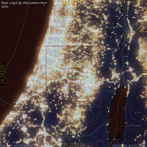
Analysis of Bayt Liqyā night lights 2016
Square area 10x10 km:
 7.33%
7.33%90-99
8.97%80-89
10.26%70-79
11.17%60-69
4.58%50-59
21.43%40-49
19.6%30-39
16.67%20-29
0%10-19
0%0-9
0%Square area 50x50 km:
15.73%90-99
13.71%80-89
12.24%70-79
10.98%60-69
7%50-59
9.42%40-49
10.49%30-39
7.98%20-29
6.93%10-19
3.99%0-9
1.53%Clear (daylight) street map image can be seen on geolist.org.
Map coordinates:
32° 27' 53.2" North, 34° 21' 44.2" East
31° 52' 10.5" North, 35° 3' 55.4" East
31° 16' 13.9" North, 35° 46' 6.7" East
Some cities around Bayt Liqyā sort by population:
• Modi‘in Makkabbim Re‘ut, IL
5.5 km =3.4 mi,  299°
299°
• Modiin Ilit, IL
7.2 km =4.5 mi,  343°
343°
• Baytūnyā
10.4 km =6.5 mi,  73°
73°
• Givat Zeev
9.8 km =6.1 mi,  95°
95°
• Qaţanah
6.4 km =4 mi,  128°
128°
• Biddū
8.8 km =5.5 mi,  115°
115°
• Abū Ghaush, IL
8.2 km =5.1 mi,  149°
149°
• Kharbathā al Mişbāḩ
1.9 km =1.2 mi,  19°
19°
284312 (p: 7,795)
Sources (retrieved 2019-11-25):
» Earth at Night: Flat Maps 2012, 2016