Givat Zeev night lights from space
Night Light of Givat Zeev (West Bank) from space (Palestinian Territory) Src. Average luminocity for 10x10km area is 86.022% and for 50x50km: 55.5143%.
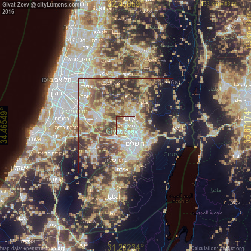
Analysis of Givat Zeev night lights 2016
Square area 10x10 km:
 24.54%
90-99
27.66%80-89
21.06%70-79
10.81%60-69
6.59%50-59
4.76%40-49
4.4%30-39
0.18%20-29
0%10-19
0%0-9
0%Square area 50x50 km:
9.63%90-99
9.88%80-89
10.94%70-79
10.55%60-69
6.36%50-59
8.88%40-49
10.31%30-39
7.18%20-29
7.45%10-19
6.9%0-9
11.92%Clear (daylight) street map image can be seen on geolist.org.
Map coordinates:
32° 27' 24.1" North, 34° 27' 55.8" East
31° 51' 41.2" North, 35° 10' 7" East
31° 15' 44.4" North, 35° 52' 18.3" East
Some cities around Givat Zeev sort by population:
• Al Bīrah
7 km =4.3 mi,  39°
39°
• Kalandia
4.6 km =2.9 mi,  82°
82°
• Ar Rām wa Ḑāḩiyat al Barīd
6.3 km =3.9 mi,  102°
102°
• Ramallah
5.4 km =3.4 mi, 38°
• Mevasseret Ẕiyyon, IL
6.8 km =4.2 mi,  194°
194°
• Baytūnyā
3.9 km =2.4 mi,  2°
2°
• Qaţanah
5.6 km =3.5 mi,  236°
236°
• Biddū
3.5 km =2.2 mi,  211°
211°
8199386 (p: 11,764)
Sources (retrieved 2019-11-25):
» Earth at Night: Flat Maps 2012, 2016