As Samū‘ night lights from space
Night Light of As Samū‘ (West Bank) from space (Palestinian Territory) Src. Average luminocity for 10x10km area is 39.1958% and for 50x50km: 27.3925%.
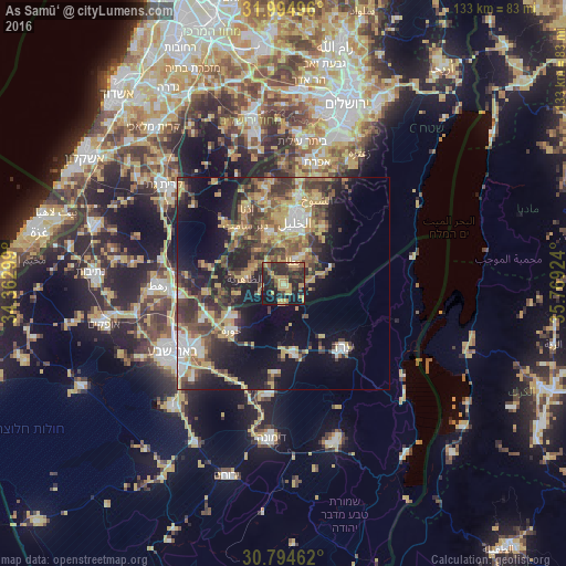
Analysis of As Samū‘ night lights 2016
Square area 10x10 km:
 0%
0%90-99
0.35%80-89
4.72%70-79
18.01%60-69
3.32%50-59
5.94%40-49
7.52%30-39
5.59%20-29
27.45%10-19
24.3%0-9
2.8%Square area 50x50 km:
2.31%90-99
2.75%80-89
3.55%70-79
7.59%60-69
2.33%50-59
4.14%40-49
6.13%30-39
6.06%20-29
7.7%10-19
15.33%0-9
42.11%Clear (daylight) street map image can be seen on geolist.org.
Map coordinates:
31° 59' 41.9" North, 34° 21' 46.8" East
31° 23' 48.2" North, 35° 3' 58" East
30° 47' 40.6" North, 35° 46' 9.3" East
Some cities around As Samū‘ sort by population:
• Hebron
15 km =9.3 mi,  10°
10°
• Yuta
6.1 km =3.8 mi,  26°
26°
• Az̧ Z̧āhirīyah
8.9 km =5.5 mi,  279°
279°
• Dūrā
12.8 km =8 mi,  344°
344°
• Banī Na‘īm
16.2 km =10.1 mi,  35°
35°
• Taffūḩ
15.8 km =9.8 mi,  354°
354°
• Bayt ‘Awwā
16.7 km =10.4 mi,  318°
318°
• Dayr Sāmit
16.3 km =10.1 mi,  327°
327°
284583 (p: 19,355)
Sources (retrieved 2019-11-25):
» Earth at Night: Flat Maps 2012, 2016