Banī Na‘īm night lights from space
Night Light of Banī Na‘īm (West Bank) from space (Palestinian Territory) Src. Average luminocity for 10x10km area is 39.778% and for 50x50km: 28.1606%.
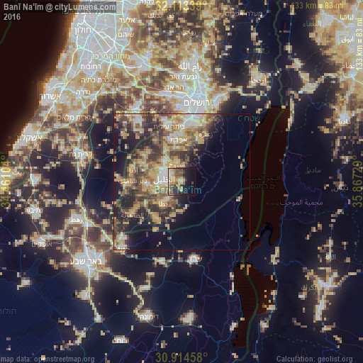
Analysis of Banī Na‘īm night lights 2016
Square area 10x10 km:
 2.27%
2.27%90-99
5.77%80-89
4.2%70-79
12.06%60-69
4.37%50-59
7.17%40-49
9.09%30-39
8.92%20-29
7.34%10-19
18.36%0-9
20.45%Square area 50x50 km:
2.45%90-99
3.16%80-89
4.35%70-79
7.53%60-69
3.15%50-59
5.16%40-49
6.37%30-39
5.28%20-29
7.5%10-19
10.28%0-9
44.78%Clear (daylight) street map image can be seen on geolist.org.
Map coordinates:
32° 6' 48.2" North, 34° 27' 39.7" East
31° 30' 57.3" North, 35° 9' 51" East
30° 54' 52.5" North, 35° 52' 2.2" East
Some cities around Banī Na‘īm sort by population:
• Hebron
6.8 km =4.2 mi,  282°
282°
• Yuta
10.2 km =6.3 mi,  220°
220°
• Ḩalḩūl
9.3 km =5.8 mi,  320°
320°
• Sa‘īr
7.3 km =4.5 mi,  341°
341°
• Bayt Fajjār
12.1 km =7.5 mi,  355°
355°
• Taffūḩ
11.1 km =6.9 mi, 283°
• Ash Shuyūkh
6.1 km =3.8 mi,  352°
352°
• Bayt Kāḩil
11.2 km =7 mi,  302°
302°
284431 (p: 19,783)
Sources (retrieved 2019-11-25):
» Earth at Night: Flat Maps 2012, 2016