Florida night lights from space
Night Light of Florida from space (Puerto Rico) Src. Average luminocity for 10x10km area is 21.5186% and for 50x50km: 19.0679%.
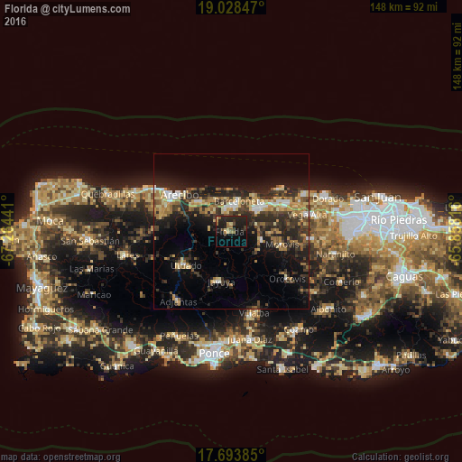
Analysis of Florida night lights 2016
Square area 10x10 km:
 0%
0%90-99
0%80-89
4.55%70-79
1.24%60-69
5.99%50-59
1.45%40-49
3.51%30-39
4.34%20-29
17.15%10-19
22.52%0-9
39.26%Square area 50x50 km:
1.36%90-99
1.65%80-89
3.01%70-79
2.78%60-69
3.57%50-59
1.85%40-49
3.13%30-39
5.14%20-29
8.56%10-19
11.54%0-9
57.4%Clear (daylight) street map image can be seen on geolist.org.
Map coordinates:
19° 1' 42.5" North, 67° 15' 51.9" West
18° 21' 44.8" North, 66° 33' 40.6" West
17° 41' 37.9" North, 65° 51' 29.4" West
Some cities around Florida sort by population:
• Arecibo
20.4 km =12.7 mi,  306°
306°
• Barceloneta
10.1 km =6.3 mi,  13°
13°
• Manatí
10.3 km =6.4 mi,  45°
45°
• Utuado
18.2 km =11.3 mi,  233°
233°
• Estancias de Florida
1 km =0.6 mi,  297°
297°
• Jayuya
16.3 km =10.1 mi,  191°
191°
• Ciales
10.2 km =6.3 mi,  106°
106°
• Morovis
16.8 km =10.4 mi,  104°
104°
4564991 (p: 5,652)
Sources (retrieved 2019-11-25):
» Earth at Night: Flat Maps 2012, 2016