Utuado night lights from space
Night Light of Utuado from space (Puerto Rico) Src. Average luminocity for 10x10km area is 19.9421% and for 50x50km: 21.5141%.
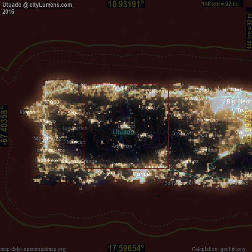
Analysis of Utuado night lights 2016
Square area 10x10 km:
 1.03%
1.03%90-99
1.24%80-89
3.31%70-79
2.69%60-69
3.31%50-59
3.1%40-49
0.41%30-39
8.06%20-29
4.55%10-19
10.54%0-9
61.78%Square area 50x50 km:
1.23%90-99
1.71%80-89
3.74%70-79
3.31%60-69
4.23%50-59
2.5%40-49
3.17%30-39
5.58%20-29
8.98%10-19
15.19%0-9
50.35%Clear (daylight) street map image can be seen on geolist.org.
Map coordinates:
18° 55' 54.9" North, 67° 24' 12.9" West
18° 15' 55.8" North, 66° 42' 1.6" West
17° 35' 47.5" North, 65° 59' 50.4" West
Some cities around Utuado sort by population:
• Arecibo
23.1 km =14.4 mi,  355°
355°
• Lares
18.9 km =11.7 mi,  279°
279°
• Peñuelas
23.4 km =14.5 mi,  185°
185°
• Estancias de Florida
17.8 km =11.1 mi,  50°
50°
• Florida
18.2 km =11.3 mi, 53°
• Adjuntas
11.7 km =7.3 mi, 191°
• Jayuya
12.6 km =7.8 mi,  114°
114°
• Ciales
25.7 km =16 mi,  72°
72°
4568490 (p: 9,844)
Sources (retrieved 2019-11-25):
» Earth at Night: Flat Maps 2012, 2016