Estancias de Florida night lights from space
Night Light of Estancias de Florida (Florida) from space (Puerto Rico) Src. Average luminocity for 10x10km area is 23.7087% and for 50x50km: 18.8493%.
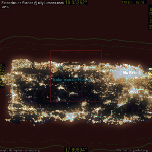
Analysis of Estancias de Florida night lights 2016
Square area 10x10 km:
 0%
0%90-99
0%80-89
5.58%70-79
1.45%60-69
5.99%50-59
2.07%40-49
4.75%30-39
5.37%20-29
18.18%10-19
21.49%0-9
35.12%Square area 50x50 km:
1.34%90-99
1.61%80-89
2.95%70-79
2.92%60-69
3.64%50-59
1.82%40-49
2.96%30-39
4.92%20-29
8.41%10-19
11.28%0-9
58.15%Clear (daylight) street map image can be seen on geolist.org.
Map coordinates:
19° 1' 57.4" North, 67° 16' 21.9" West
18° 21' 59.8" North, 66° 34' 10.6" West
17° 41' 52.9" North, 65° 51' 59.4" West
Some cities around Estancias de Florida sort by population:
• Arecibo
19.4 km =12.1 mi,  307°
307°
• Barceloneta
9.9 km =6.2 mi,  19°
19°
• Manatí
10.6 km =6.6 mi,  50°
50°
• Utuado
17.8 km =11.1 mi,  230°
230°
• Florida
1 km =0.6 mi,  117°
117°
• Jayuya
16.6 km =10.3 mi,  188°
188°
• Ciales
11.2 km =7 mi,  107°
107°
• Morovis
17.8 km =11.1 mi,  104°
104°
4564901 (p: 5,972)
Sources (retrieved 2019-11-25):
» Earth at Night: Flat Maps 2012, 2016