Morovis night lights from space
Night Light of Morovis from space (Puerto Rico) Src. Average luminocity for 10x10km area is 30.1983% and for 50x50km: 28.2717%.
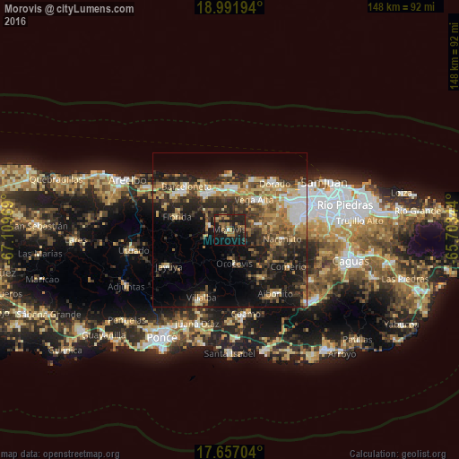
Analysis of Morovis night lights 2016
Square area 10x10 km:
100  0.62%
0.62%
90-99 0.21%
80-89 1.65%
70-79 4.75%
60-69 12.4%
50-59 4.34%
40-49 2.89%
30-39 8.47%
20-29 20.66%
10-19 31.61%
0-9 12.4%
0.62%90-99
0.21%80-89
1.65%70-79
4.75%60-69
12.4%50-59
4.34%40-49
2.89%30-39
8.47%20-29
20.66%10-19
31.61%0-9
12.4%Square area 50x50 km:
100 2.93%
90-99 3.16%
80-89 4.07%
70-79 3.89%
60-69 5.89%
50-59 3.48%
40-49 4.87%
30-39 6.94%
20-29 9.7%
10-19 16.54%
0-9 38.53%
2.93%90-99
3.16%80-89
4.07%70-79
3.89%60-69
5.89%50-59
3.48%40-49
4.87%30-39
6.94%20-29
9.7%10-19
16.54%0-9
38.53%Clear (daylight) street map image can be seen on geolist.org.
Map coordinates:
18° 59' 31" North, 67° 6' 34.9" West
18° 19' 32.8" North, 66° 24' 23.6" West
17° 39' 25.3" North, 65° 42' 12.4" West
Some cities around Morovis sort by population:
• Vega Baja
13.3 km =8.3 mi,  8°
8°
• Manatí
14.5 km =9 mi,  321°
321°
• Vega Alta
12.5 km =7.8 mi,  39°
39°
• Corozal
9.6 km =6 mi,  79°
79°
• Ceiba
14.6 km =9.1 mi,  23°
23°
• Florida
16.8 km =10.4 mi,  284°
284°
• Ciales
6.7 km =4.2 mi, 279°
• Orocovis
11.1 km =6.9 mi,  171°
171°
4566333 (p: 2,414)
Sources (retrieved 2019-11-25):
» Earth at Night: Flat Maps 2012, 2016