Ceiba night lights from space
Night Light of Ceiba from space (Puerto Rico) Src. Average luminocity for 10x10km area is 31.9855% and for 50x50km: 14.8596%.
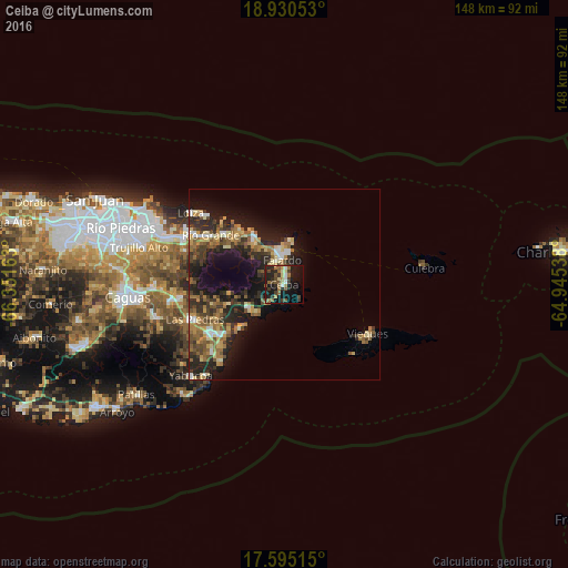
Analysis of Ceiba night lights 2016
Square area 10x10 km:
 1.45%
1.45%90-99
3.31%80-89
4.75%70-79
1.65%60-69
7.44%50-59
6.2%40-49
7.85%30-39
6.4%20-29
10.74%10-19
32.23%0-9
17.98%Square area 50x50 km:
1.01%90-99
1.36%80-89
2.18%70-79
1.8%60-69
3.14%50-59
2.75%40-49
2.53%30-39
3.35%20-29
5.4%10-19
10.86%0-9
65.61%Clear (daylight) street map image can be seen on geolist.org.
Map coordinates:
18° 55' 49.9" North, 66° 21' 5.9" West
18° 15' 50.8" North, 65° 38' 54.6" West
17° 35' 42.5" North, 64° 56' 43.4" West
Some cities around Ceiba sort by population:
• Fajardo
6.9 km =4.3 mi,  356°
356°
• Humacao
22.8 km =14.2 mi,  236°
236°
• Río Grande
23.2 km =14.4 mi,  303°
303°
• Isabel Segunda
25.2 km =15.7 mi,  120°
120°
• Luquillo
14 km =8.7 mi,  329°
329°
• Las Piedras
24.7 km =15.3 mi,  248°
248°
• Punta Santiago
15.1 km =9.4 mi,  224°
224°
• Naguabo
10.8 km =6.7 mi, 237°
4563378 (p: 6,277)
Sources (retrieved 2019-11-25):
» Earth at Night: Flat Maps 2012, 2016