Zakrzów night lights from space
Night Light of Zakrzów (Lower Silesia) from space (Poland) Src. Average luminocity for 10x10km area is 44.5094% and for 50x50km: 15.6038%.
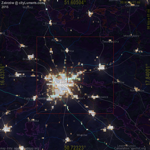
Analysis of Zakrzów night lights 2016
Square area 10x10 km:
 8.42%
8.42%90-99
10.43%80-89
4.01%70-79
5.88%60-69
3.88%50-59
2.94%40-49
5.75%30-39
9.49%20-29
16.58%10-19
30.75%0-9
1.87%Square area 50x50 km:
4.03%90-99
3.68%80-89
1.1%70-79
1.14%60-69
1.38%50-59
1.54%40-49
1.72%30-39
2.11%20-29
3.68%10-19
7.67%0-9
71.96%Clear (daylight) street map image can be seen on geolist.org.
Map coordinates:
51° 36' 18.1" North, 16° 26' 1.5" East
51° 9' 58.5" North, 17° 8' 12.8" East
50° 43' 23.6" North, 17° 50' 24" East
Some cities around Zakrzów sort by population:
• Rejon placu Grunwaldzkiego
7.6 km =4.7 mi,  223°
223°
• Różanka-Polanka
8.5 km =5.3 mi,  252°
252°
• Karłowice
6.5 km =4 mi,  244°
244°
• Zgorzelisko
3.1 km =1.9 mi,  184°
184°
• Biskupin
7.6 km =4.7 mi,  197°
197°
• Sępolno
6.7 km =4.2 mi, 201°
• Rejon ulicy Klęczkowskiej
8.3 km =5.2 mi, 240°
• Psie Pole Południe-Kiełczów
2.2 km =1.4 mi, 197°
12047624 (p: 10,737)
Sources (retrieved 2019-11-25):
» Earth at Night: Flat Maps 2012, 2016