Karłowice night lights from space
Night Light of Karłowice (Lower Silesia) from space (Poland) Src. Average luminocity for 10x10km area is 80.3035% and for 50x50km: 16.4825%.
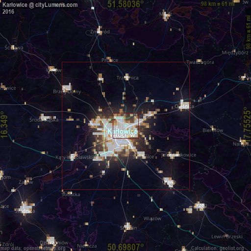
Analysis of Karłowice night lights 2016
Square area 10x10 km:
 34.22%
90-99
24.6%80-89
6.55%70-79
5.61%60-69
5.61%50-59
3.21%40-49
5.75%30-39
8.82%20-29
5.61%10-19
0%0-9
0%Square area 50x50 km:
4.3%90-99
3.91%80-89
1.19%70-79
1.27%60-69
1.42%50-59
1.53%40-49
1.72%30-39
2.1%20-29
3.7%10-19
7.84%0-9
71.02%Clear (daylight) street map image can be seen on geolist.org.
Map coordinates:
51° 34' 49.3" North, 16° 20' 56.4" East
51° 8' 28.8" North, 17° 3' 7.6" East
50° 41' 53.1" North, 17° 45' 18.9" East
Some cities around Karłowice sort by population:
• Wrocław
4.8 km =3 mi,  195°
195°
• Rejon placu Świętego Macieja
2.5 km =1.6 mi, 203°
• Rejon placu Grunwaldzkiego
2.8 km =1.7 mi,  166°
166°
• Rejon ulicy Traugutta
4.3 km =2.7 mi,  183°
183°
• Różanka-Polanka
2.3 km =1.4 mi,  275°
275°
• Sępolno
4.9 km =3 mi,  135°
135°
• Rejon ulicy Klęczkowskiej
1.8 km =1.1 mi,  224°
224°
• Psie Pole Południe-Kiełczów
5.3 km =3.3 mi,  82°
82°
12047659 (p: 12,651)
Sources (retrieved 2019-11-25):
» Earth at Night: Flat Maps 2012, 2016