Różanka-Polanka night lights from space
Night Light of Różanka-Polanka (Lower Silesia) from space (Poland) Src. Average luminocity for 10x10km area is 77.9719% and for 50x50km: 16.2115%.
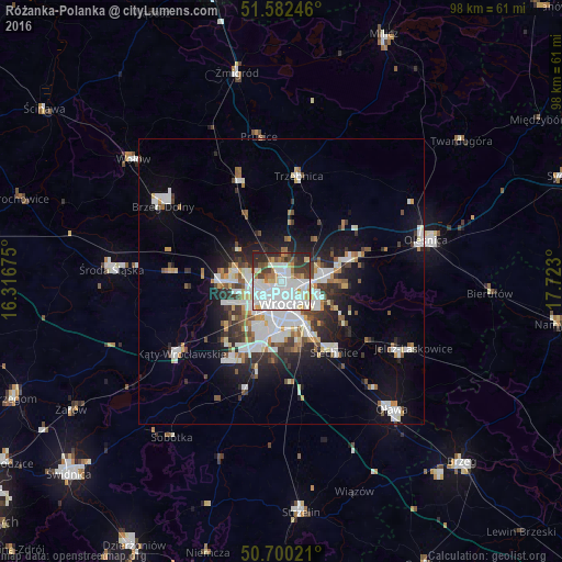
Analysis of Różanka-Polanka night lights 2016
Square area 10x10 km:
 34.63%
90-99
23.26%80-89
4.81%70-79
4.68%60-69
5.61%50-59
3.74%40-49
5.21%30-39
7.89%20-29
9.89%10-19
0.27%0-9
0%Square area 50x50 km:
4.2%90-99
3.8%80-89
1.15%70-79
1.27%60-69
1.42%50-59
1.55%40-49
1.74%30-39
2.1%20-29
3.67%10-19
7.47%0-9
71.64%Clear (daylight) street map image can be seen on geolist.org.
Map coordinates:
51° 34' 56.9" North, 16° 19' 0.3" East
51° 8' 36.4" North, 17° 1' 11.5" East
50° 42' 0.8" North, 17° 43' 22.8" East
Some cities around Różanka-Polanka sort by population:
• Rejon placu Świętego Macieja
2.8 km =1.7 mi,  154°
154°
• Rejon placu Grunwaldzkiego
4.1 km =2.5 mi,  135°
135°
• Osiedle Kosmonautów
4.4 km =2.7 mi,  246°
246°
• Kozanów
3.5 km =2.2 mi,  271°
271°
• Karłowice
2.3 km =1.4 mi,  95°
95°
• Gądów Mały
3.6 km =2.2 mi,  220°
220°
• Rejon ulicy Klęczkowskiej
1.8 km =1.1 mi, 147°
• Pilczyce
4.4 km =2.7 mi,  260°
260°
12047651 (p: 15,746)
Sources (retrieved 2019-11-25):
» Earth at Night: Flat Maps 2012, 2016