Rejon ulicy Klęczkowskiej night lights from space
Night Light of Rejon ulicy Klęczkowskiej (Lower Silesia) from space (Poland) Src. Average luminocity for 10x10km area is 84.5709% and for 50x50km: 16.3467%.
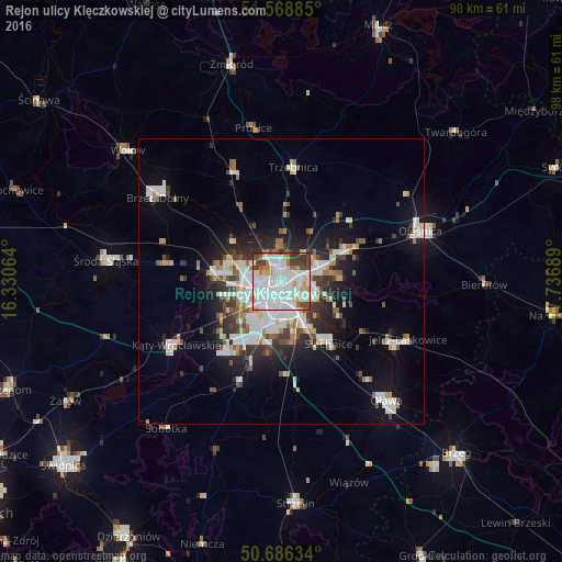
Analysis of Rejon ulicy Klęczkowskiej night lights 2016
Square area 10x10 km:
 39.44%
90-99
26.74%80-89
5.75%70-79
4.68%60-69
4.81%50-59
2.67%40-49
7.75%30-39
6.82%20-29
1.34%10-19
0%0-9
0%Square area 50x50 km:
4.24%90-99
3.83%80-89
1.17%70-79
1.27%60-69
1.44%50-59
1.53%40-49
1.72%30-39
2.1%20-29
3.69%10-19
7.69%0-9
71.32%Clear (daylight) street map image can be seen on geolist.org.
Map coordinates:
51° 34' 7.9" North, 16° 19' 50.3" East
51° 7' 46.9" North, 17° 2' 1.5" East
50° 41' 10.8" North, 17° 44' 12.8" East
Some cities around Rejon ulicy Klęczkowskiej sort by population:
• Wrocław
3.3 km =2.1 mi,  180°
180°
• Kozanów
4.8 km =3 mi,  290°
290°
• Różanka-Polanka
1.8 km =1.1 mi,  327°
327°
• Karłowice
1.8 km =1.1 mi,  44°
44°
• Powstańców Śląskich Zachód-Centrum Południow
3.9 km =2.4 mi,  196°
196°
• Powstańców Śląskich Wschód
4.3 km =2.7 mi,  188°
188°
• Gądów Mały
3.6 km =2.2 mi,  249°
249°
• Osiedle Henrykowskie
4.6 km =2.9 mi,  163°
163°
12047609 (p: 6,223)
Sources (retrieved 2019-11-25):
» Earth at Night: Flat Maps 2012, 2016