Wilanów night lights from space
Night Light of Wilanów (Mazovia) from space (Poland) Src. Average luminocity for 10x10km area is 80.5463% and for 50x50km: 40.2555%.
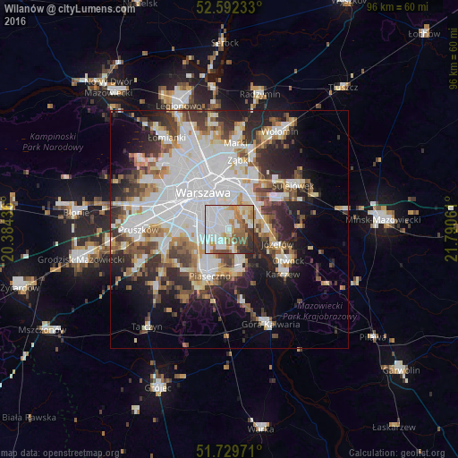
Analysis of Wilanów night lights 2016
Square area 10x10 km:
 35.32%
90-99
18.78%80-89
6.22%70-79
9.13%60-69
10.05%50-59
6.48%40-49
4.23%30-39
5.69%20-29
4.1%10-19
0%0-9
0%Square area 50x50 km:
13.6%90-99
8.68%80-89
3.49%70-79
3.54%60-69
4.05%50-59
4.17%40-49
4.21%30-39
5.17%20-29
7.65%10-19
9.91%0-9
35.54%Clear (daylight) street map image can be seen on geolist.org.
Map coordinates:
52° 35' 32.4" North, 20° 23' 3.7" East
52° 9' 47.2" North, 21° 5' 14.9" East
51° 43' 47" North, 21° 47' 26.2" East
Some cities around Wilanów sort by population:
• Warsaw
9 km =5.6 mi,  325°
325°
• Mokotów
4.9 km =3 mi,  313°
313°
• Praga Południe
9 km =5.6 mi,  359°
359°
• Ursynów
2.9 km =1.8 mi,  241°
241°
• Śródmieście
8.8 km =5.5 mi, 326°
• Wawer
7.2 km =4.5 mi,  58°
58°
• Kabaty
3.7 km =2.3 mi,  186°
186°
• Konstancin-Jeziorna
8 km =5 mi,  165°
165°
755726 (p: 14,032)
Sources (retrieved 2019-11-25):
» Earth at Night: Flat Maps 2012, 2016