Powstańców Śląskich Zachód-Centrum Południow night lights from space
Night Light of Powstańców Śląskich Zachód-Centrum Południow (Lower Silesia) from space (Poland) Src. Average luminocity for 10x10km area is 94.8636% and for 50x50km: 16.3074%.
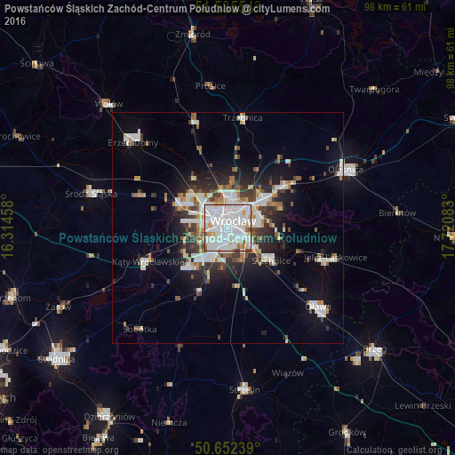
Analysis of Powstańców Śląskich Zachód-Centrum Południow night lights 2016
Square area 10x10 km:
 50.4%
50.4%90-99
34.36%80-89
5.08%70-79
4.55%60-69
2.27%50-59
1.87%40-49
1.34%30-39
0.13%20-29
0%10-19
0%0-9
0%Square area 50x50 km:
4.19%90-99
3.82%80-89
1.14%70-79
1.27%60-69
1.44%50-59
1.58%40-49
1.77%30-39
2.13%20-29
3.66%10-19
7.59%0-9
71.43%Clear (daylight) street map image can be seen on geolist.org.
Map coordinates:
51° 32' 7.9" North, 16° 18' 52.5" East
51° 5' 45.9" North, 17° 1' 3.7" East
50° 39' 8.6" North, 17° 43' 15" East
Some cities around Powstańców Śląskich Zachód-Centrum Południow sort by population:
• Wrocław
1.2 km =0.7 mi,  68°
68°
• Rejon placu Świętego Macieja
3.1 km =1.9 mi,  27°
27°
• Rejon ulicy Traugutta
2.3 km =1.4 mi, 71°
• Krzyki
3.2 km =2 mi,  209°
209°
• Grabiszynek
2.4 km =1.5 mi,  245°
245°
• Gądów Mały
3.3 km =2.1 mi,  318°
318°
• Rejon ulicy Mieleckiej
1.2 km =0.7 mi,  244°
244°
• Osiedle Henrykowskie
2.5 km =1.6 mi,  105°
105°
12047655 (p: 12,077)
Sources (retrieved 2019-11-25):
» Earth at Night: Flat Maps 2012, 2016