Kozanów night lights from space
Night Light of Kozanów (Lower Silesia) from space (Poland) Src. Average luminocity for 10x10km area is 76.381% and for 50x50km: 15.9906%.
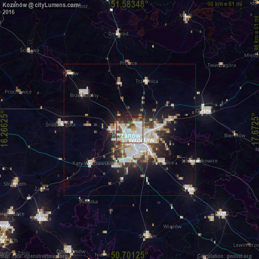
Analysis of Kozanów night lights 2016
Square area 10x10 km:
 33.42%
90-99
22.46%80-89
3.61%70-79
6.15%60-69
4.28%50-59
5.88%40-49
5.88%30-39
6.42%20-29
11.1%10-19
0.8%0-9
0%Square area 50x50 km:
4.14%90-99
3.74%80-89
1.11%70-79
1.28%60-69
1.41%50-59
1.59%40-49
1.78%30-39
2.06%20-29
3.69%10-19
7.12%0-9
72.08%Clear (daylight) street map image can be seen on geolist.org.
Map coordinates:
51° 35' 0.5" North, 16° 15' 58.5" East
51° 8' 40.1" North, 16° 58' 9.7" East
50° 42' 4.5" North, 17° 40' 21" East
Some cities around Kozanów sort by population:
• Rejon placu Świętego Macieja
5.5 km =3.4 mi,  119°
119°
• Osiedle Kosmonautów
2 km =1.2 mi,  195°
195°
• Różanka-Polanka
3.5 km =2.2 mi,  91°
91°
• Stabłowice
4.9 km =3 mi,  282°
282°
• Gądów Mały
3.1 km =1.9 mi,  158°
158°
• Maślice Małe
2 km =1.2 mi,  285°
285°
• Rejon ulicy Klęczkowskiej
4.8 km =3 mi,  110°
110°
• Pilczyce
1.2 km =0.7 mi,  225°
225°
12047636 (p: 15,901)
Sources (retrieved 2019-11-25):
» Earth at Night: Flat Maps 2012, 2016