Raszyn night lights from space
Night Light of Raszyn (Mazovia) from space (Poland) Src. Average luminocity for 10x10km area is 84.1706% and for 50x50km: 41.9452%.
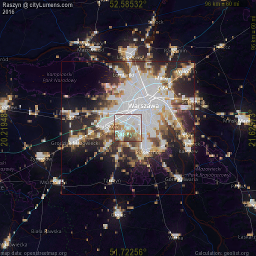
Analysis of Raszyn night lights 2016
Square area 10x10 km:
100  32.94%
90-99 26.98%
80-89 4.23%
70-79 8.73%
60-69 12.3%
50-59 6.22%
40-49 5.56%
30-39 3.04%
20-29 0%
10-19 0%
0-9 0%
32.94%90-99
26.98%80-89
4.23%70-79
8.73%60-69
12.3%50-59
6.22%40-49
5.56%30-39
3.04%20-29
0%10-19
0%0-9
0%Square area 50x50 km:
100 13.94%
90-99 9.19%
80-89 3.42%
70-79 3.68%
60-69 4.38%
50-59 4.35%
40-49 4.51%
30-39 4.91%
20-29 9.07%
10-19 11.15%
0-9 31.4%
13.94%90-99
9.19%80-89
3.42%70-79
3.68%60-69
4.38%50-59
4.35%40-49
4.51%30-39
4.91%20-29
9.07%10-19
11.15%0-9
31.4%Clear (daylight) street map image can be seen on geolist.org.
Map coordinates:
52° 35' 7.2" North, 20° 13' 10.1" East
52° 9' 21.7" North, 20° 55' 21.4" East
51° 43' 21.2" North, 21° 37' 32.6" East
Some cities around Raszyn sort by population:
• Mokotów
8.7 km =5.4 mi,  61°
61°
• Ochota
8.4 km =5.2 mi,  30°
30°
• Pruszków
7.7 km =4.8 mi,  282°
282°
• Ursus
5.1 km =3.2 mi,  328°
328°
• Włochy
3.1 km =1.9 mi, 31°
• Piastów
6.5 km =4 mi,  299°
299°
• Lesznowola
7.3 km =4.5 mi,  173°
173°
• Komorów
7.4 km =4.6 mi,  260°
260°
760607 (p: 7,109)
Sources (retrieved 2019-11-25):
» Earth at Night: Flat Maps 2012, 2016