Lesznowola night lights from space
Night Light of Lesznowola (Mazovia) from space (Poland) Src. Average luminocity for 10x10km area is 60.1772% and for 50x50km: 37.0856%.
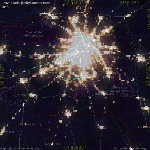
Analysis of Lesznowola night lights 2016
Square area 10x10 km:
 7.28%
7.28%90-99
10.71%80-89
9.66%70-79
8.2%60-69
13.89%50-59
12.3%40-49
10.71%30-39
13.23%20-29
13.76%10-19
0.26%0-9
0%Square area 50x50 km:
12.91%90-99
7.84%80-89
2.84%70-79
3.03%60-69
3.86%50-59
4.09%40-49
3.77%30-39
3.98%20-29
7.58%10-19
10.73%0-9
39.37%Clear (daylight) street map image can be seen on geolist.org.
Map coordinates:
52° 31' 15.1" North, 20° 13' 54" East
52° 5' 27.4" North, 20° 56' 5.2" East
51° 39' 24.7" North, 21° 38' 16.5" East
Some cities around Lesznowola sort by population:
• Ursynów
10.3 km =6.4 mi,  50°
50°
• Ursus
12.1 km =7.5 mi,  343°
343°
• Piaseczno
6.2 km =3.9 mi,  99°
99°
• Włochy
9.9 km =6.2 mi,  4°
4°
• Kabaty
10.9 km =6.8 mi,  66°
66°
• Nadarzyn
8.7 km =5.4 mi,  272°
272°
• Raszyn
7.3 km =4.5 mi,  353°
353°
• Komorów
10.2 km =6.3 mi,  306°
306°
766369 (p: 5,374)
Sources (retrieved 2019-11-25):
» Earth at Night: Flat Maps 2012, 2016