Piastów night lights from space
Night Light of Piastów (Mazovia) from space (Poland) Src. Average luminocity for 10x10km area is 90.3585% and for 50x50km: 40.3004%.
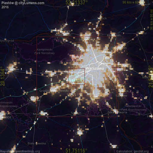

Analysis of Piastów night lights 2016
Square area 10x10 km:
100  40.08%
90-99 33.33%
80-89 3.7%
70-79 9.13%
60-69 5.69%
50-59 5.42%
40-49 1.59%
30-39 1.06%
20-29 0%
10-19 0%
0-9 0%
40.08%90-99
33.33%80-89
3.7%70-79
9.13%60-69
5.69%50-59
5.42%40-49
1.59%30-39
1.06%20-29
0%10-19
0%0-9
0%Square area 50x50 km:
100 13.63%
90-99 8.77%
80-89 3.16%
70-79 3.45%
60-69 4.3%
50-59 4.08%
40-49 4.29%
30-39 4.75%
20-29 7.73%
10-19 11.25%
0-9 34.59%
13.63%90-99
8.77%80-89
3.16%70-79
3.45%60-69
4.3%50-59
4.08%40-49
4.29%30-39
4.75%20-29
7.73%10-19
11.25%0-9
34.59%Clear (daylight) street map image can be seen on geolist.org.
Map coordinates:
52° 36' 48.1" North, 20° 8' 11" East
52° 11' 3.7" North, 20° 50' 22.3" East
51° 45' 4.2" North, 21° 32' 33.5" East
Some cities around Piastów sort by population:
• Bemowo
9.1 km =5.7 mi,  31°
31°
• Pruszków
2.4 km =1.5 mi,  230°
230°
• Ursus
3.3 km =2.1 mi,  68°
68°
• Włochy
7.3 km =4.5 mi,  94°
94°
• Brwinów
9.6 km =6 mi,  241°
241°
• Ożarów Mazowiecki
4.1 km =2.5 mi,  315°
315°
• Raszyn
6.5 km =4 mi,  119°
119°
• Komorów
4.6 km =2.9 mi,  200°
200°
762381 (p: 23,290)
Sources (retrieved 2019-11-25):
» Earth at Night: Flat Maps 2012, 2016