Brwinów night lights from space
Night Light of Brwinów (Mazovia) from space (Poland) Src. Average luminocity for 10x10km area is 52.1124% and for 50x50km: 31.4379%.
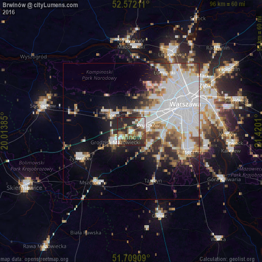
Analysis of Brwinów night lights 2016
Square area 10x10 km:
 7.41%
7.41%90-99
12.3%80-89
3.7%70-79
5.29%60-69
7.14%50-59
10.32%40-49
9.52%30-39
7.14%20-29
32.94%10-19
4.23%0-9
0%Square area 50x50 km:
11.63%90-99
6.84%80-89
2.11%70-79
2.39%60-69
3.11%50-59
3.05%40-49
3.24%30-39
3.02%20-29
5%10-19
8.37%0-9
51.24%Clear (daylight) street map image can be seen on geolist.org.
Map coordinates:
52° 34' 19.6" North, 20° 0' 49.9" East
52° 8' 33.7" North, 20° 43' 1.1" East
51° 42' 32.7" North, 21° 25' 12.4" East
Some cities around Brwinów sort by population:
• Pruszków
7.2 km =4.5 mi,  64°
64°
• Grodzisk Mazowiecki
7.1 km =4.4 mi,  232°
232°
• Piastów
9.6 km =6 mi, 61°
• Milanówek
4.1 km =2.5 mi, 229°
• Błonie
9.2 km =5.7 mi,  312°
312°
• Nadarzyn
8.2 km =5.1 mi,  130°
130°
• Ożarów Mazowiecki
9.3 km =5.8 mi,  35°
35°
• Komorów
6.7 km =4.2 mi,  87°
87°
775224 (p: 12,315)
Sources (retrieved 2019-11-25):
» Earth at Night: Flat Maps 2012, 2016