Ożarów Mazowiecki night lights from space
Night Light of Ożarów Mazowiecki (Mazovia) from space (Poland) Src. Average luminocity for 10x10km area is 71.9206% and for 50x50km: 38.9301%.
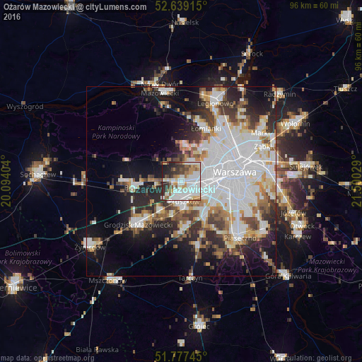
Analysis of Ożarów Mazowiecki night lights 2016
Square area 10x10 km:
 25%
25%90-99
22.09%80-89
4.5%70-79
7.8%60-69
5.42%50-59
7.28%40-49
5.82%30-39
7.67%20-29
9.66%10-19
4.76%0-9
0%Square area 50x50 km:
13.41%90-99
8.55%80-89
2.97%70-79
3.28%60-69
4.01%50-59
3.88%40-49
3.99%30-39
4.22%20-29
7.24%10-19
11.68%0-9
36.78%Clear (daylight) street map image can be seen on geolist.org.
Map coordinates:
52° 38' 20.9" North, 20° 5' 38.5" East
52° 12' 37.4" North, 20° 47' 49.8" East
51° 46' 38.8" North, 21° 30' 1" East
Some cities around Ożarów Mazowiecki sort by population:
• Bemowo
9 km =5.6 mi,  57°
57°
• Pruszków
4.5 km =2.8 mi,  166°
166°
• Ursus
6.2 km =3.9 mi,  105°
105°
• Włochy
10.7 km =6.6 mi, 108°
• Piastów
4.1 km =2.5 mi,  135°
135°
• Brwinów
9.3 km =5.8 mi,  215°
215°
• Raszyn
10.5 km =6.5 mi,  125°
125°
• Komorów
7.3 km =4.5 mi, 170°
762769 (p: 8,237)
Sources (retrieved 2019-11-25):
» Earth at Night: Flat Maps 2012, 2016