Nadarzyn night lights from space
Night Light of Nadarzyn (Mazovia) from space (Poland) Src. Average luminocity for 10x10km area is 46.7526% and for 50x50km: 34.2156%.
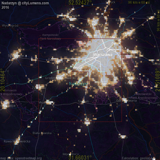
Analysis of Nadarzyn night lights 2016
Square area 10x10 km:
 4.37%
4.37%90-99
6.61%80-89
5.03%70-79
4.1%60-69
8.6%50-59
14.15%40-49
10.71%30-39
11.64%20-29
19.97%10-19
12.43%0-9
2.38%Square area 50x50 km:
12.54%90-99
7.48%80-89
2.48%70-79
2.69%60-69
3.58%50-59
3.53%40-49
3.12%30-39
3.26%20-29
5.41%10-19
9.02%0-9
46.9%Clear (daylight) street map image can be seen on geolist.org.
Map coordinates:
52° 31' 27.4" North, 20° 6' 16.7" East
52° 5' 39.8" North, 20° 48' 27.9" East
51° 39' 37.1" North, 21° 30' 39.2" East
Some cities around Nadarzyn sort by population:
• Pruszków
8.5 km =5.3 mi,  2°
2°
• Grodzisk Mazowiecki
11.9 km =7.4 mi,  275°
275°
• Piastów
10.2 km =6.3 mi,  12°
12°
• Milanówek
9.7 km =6 mi,  286°
286°
• Brwinów
8.2 km =5.1 mi,  310°
310°
• Raszyn
10.4 km =6.5 mi,  48°
48°
• Lesznowola
8.7 km =5.4 mi,  92°
92°
• Komorów
5.7 km =3.5 mi, 5°
764194 (p: 9,881)
Sources (retrieved 2019-11-25):
» Earth at Night: Flat Maps 2012, 2016