Milanówek night lights from space
Night Light of Milanówek (Mazovia) from space (Poland) Src. Average luminocity for 10x10km area is 47.6587% and for 50x50km: 26.8072%.
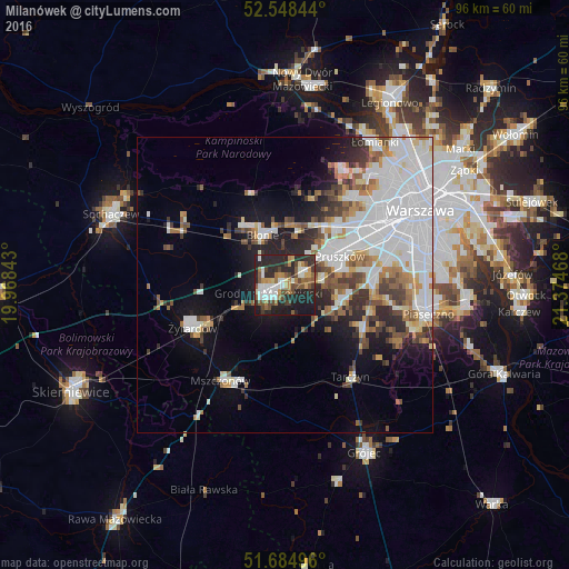
Analysis of Milanówek night lights 2016
Square area 10x10 km:
 6.48%
6.48%90-99
10.19%80-89
2.91%70-79
5.95%60-69
7.01%50-59
8.86%40-49
8.6%30-39
5.29%20-29
29.1%10-19
15.61%0-9
0%Square area 50x50 km:
9.31%90-99
5.87%80-89
1.69%70-79
2.08%60-69
2.77%50-59
2.84%40-49
2.61%30-39
2.75%20-29
4.67%10-19
8.07%0-9
57.33%Clear (daylight) street map image can be seen on geolist.org.
Map coordinates:
52° 32' 54.4" North, 19° 58' 6.3" East
52° 7' 7.6" North, 20° 40' 17.6" East
51° 41' 5.9" North, 21° 22' 28.8" East
Some cities around Milanówek sort by population:
• Pruszków
11.2 km =7 mi,  58°
58°
• Grodzisk Mazowiecki
3.1 km =1.9 mi,  237°
237°
• Piastów
13.6 km =8.5 mi, 57°
• Brwinów
4.1 km =2.5 mi,  49°
49°
• Błonie
9.6 km =6 mi,  337°
337°
• Nadarzyn
9.7 km =6 mi,  106°
106°
• Ożarów Mazowiecki
13.3 km =8.3 mi,  40°
40°
• Komorów
10.3 km =6.4 mi,  73°
73°
764749 (p: 15,784)
Sources (retrieved 2019-11-25):
» Earth at Night: Flat Maps 2012, 2016