Grójec night lights from space
Night Light of Grójec (Mazovia) from space (Poland) Src. Average luminocity for 10x10km area is 19.3321% and for 50x50km: 7.2999%.
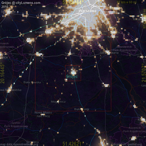
Analysis of Grójec night lights 2016
Square area 10x10 km:
 3.79%
3.79%90-99
3.03%80-89
2.27%70-79
0.76%60-69
1.89%50-59
3.54%40-49
1.26%30-39
2.65%20-29
0.51%10-19
19.82%0-9
60.48%Square area 50x50 km:
0.77%90-99
0.98%80-89
0.75%70-79
0.65%60-69
1.06%50-59
1.1%40-49
1.1%30-39
1.17%20-29
2.02%10-19
6%0-9
84.4%Clear (daylight) street map image can be seen on geolist.org.
Map coordinates:
52° 17' 40.7" North, 20° 9' 52" East
51° 51' 45.1" North, 20° 52' 3.3" East
51° 25' 34.4" North, 21° 34' 14.5" East
Some cities around Grójec sort by population:
• Piaseczno
26.6 km =16.5 mi,  23°
23°
• Konstancin-Jeziorna
30.9 km =19.2 mi,  33°
33°
• Warka
23.9 km =14.9 mi,  111°
111°
• Góra Kalwaria
27 km =16.8 mi,  62°
62°
• Nadarzyn
26.1 km =16.2 mi,  350°
350°
• Białobrzegi
24.6 km =15.3 mi,  166°
166°
• Mszczonów
26.8 km =16.7 mi,  297°
297°
• Lesznowola
25.8 km =16 mi,  10°
10°
771384 (p: 14,880)
Sources (retrieved 2019-11-25):
» Earth at Night: Flat Maps 2012, 2016