Łazy night lights from space
Night Light of Łazy (Silesia) from space (Poland) Src. Average luminocity for 10x10km area is 11.7115% and for 50x50km: 17.7891%.
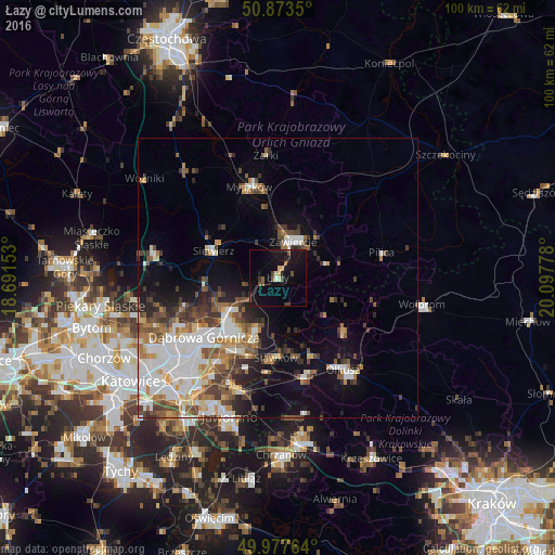
Analysis of Łazy night lights 2016
Square area 10x10 km:
 0.42%
0.42%90-99
0.84%80-89
0.98%70-79
1.12%60-69
0.28%50-59
2.38%40-49
2.94%30-39
1.12%20-29
1.26%10-19
19.19%0-9
69.47%Square area 50x50 km:
4.07%90-99
3.71%80-89
1.4%70-79
1.64%60-69
2.28%50-59
2.62%40-49
2.75%30-39
2.55%20-29
2.57%10-19
6.46%0-9
69.96%Clear (daylight) street map image can be seen on geolist.org.
Map coordinates:
50° 52' 24.6" North, 18° 41' 29.5" East
50° 25' 39.7" North, 19° 23' 40.7" East
49° 58' 39.5" North, 20° 5' 52" East
Some cities around Łazy sort by population:
• Dąbrowa Górnicza
17 km =10.6 mi,  232°
232°
• Zawiercie
6.8 km =4.2 mi,  13°
13°
• Myszków
17.1 km =10.6 mi,  343°
343°
• Bukowno
18.7 km =11.6 mi,  165°
165°
• Poręba
7.8 km =4.8 mi,  329°
329°
• Sławków
14.3 km =8.9 mi,  181°
181°
• Klucze
15.7 km =9.8 mi,  130°
130°
• Siewierz
12.4 km =7.7 mi,  290°
290°
3093768 (p: 7,166)
Sources (retrieved 2019-11-25):
» Earth at Night: Flat Maps 2012, 2016