Bukowno night lights from space
Night Light of Bukowno (Lesser Poland) from space (Poland) Src. Average luminocity for 10x10km area is 15.9492% and for 50x50km: 21.5275%.
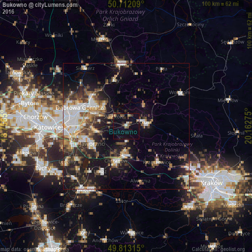
Analysis of Bukowno night lights 2016
Square area 10x10 km:
 0.67%
0.67%90-99
1.47%80-89
1.6%70-79
1.07%60-69
1.07%50-59
3.21%40-49
3.88%30-39
1.74%20-29
2.81%10-19
14.44%0-9
68.05%Square area 50x50 km:
4.02%90-99
3.75%80-89
1.69%70-79
2.14%60-69
2.72%50-59
3.06%40-49
3.53%30-39
3.81%20-29
5.56%10-19
13.34%0-9
56.38%Clear (daylight) street map image can be seen on geolist.org.
Map coordinates:
50° 42' 43.5" North, 18° 45' 23.4" East
50° 15' 53.1" North, 19° 27' 34.6" East
49° 48' 47.3" North, 20° 9' 45.9" East
Some cities around Bukowno sort by population:
• Jaworzno
14.7 km =9.1 mi,  243°
243°
• Chrzanów
14.9 km =9.3 mi,  195°
195°
• Olkusz
7.7 km =4.8 mi,  76°
76°
• Trzebinia
11.7 km =7.3 mi,  176°
176°
• Krzeszowice
18.3 km =11.4 mi,  137°
137°
• Łazy
18.7 km =11.6 mi,  345°
345°
• Sławków
6.3 km =3.9 mi,  307°
307°
• Klucze
10.7 km =6.6 mi,  42°
42°
3102076 (p: 10,874)
Sources (retrieved 2019-11-25):
» Earth at Night: Flat Maps 2012, 2016