Sławków night lights from space
Night Light of Sławków (Silesia) from space (Poland) Src. Average luminocity for 10x10km area is 23.0869% and for 50x50km: 24.4828%.
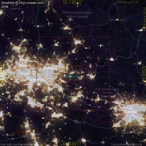
Analysis of Sławków night lights 2016
Square area 10x10 km:
 0.8%
0.8%90-99
2.54%80-89
0.94%70-79
2.81%60-69
4.14%50-59
4.81%40-49
5.08%30-39
3.21%20-29
9.76%10-19
24.2%0-9
41.71%Square area 50x50 km:
4.9%90-99
4.65%80-89
1.91%70-79
2.34%60-69
3.09%50-59
3.38%40-49
4.06%30-39
3.97%20-29
6.43%10-19
13.01%0-9
52.27%Clear (daylight) street map image can be seen on geolist.org.
Map coordinates:
50° 44' 47.2" North, 18° 41' 11.6" East
50° 17' 57.9" North, 19° 23' 22.8" East
49° 50' 53.4" North, 20° 5' 34.1" East
Some cities around Sławków sort by population:
• Dąbrowa Górnicza
13.7 km =8.5 mi,  286°
286°
• Jaworzno
13.3 km =8.3 mi,  217°
217°
• Chrzanów
18.3 km =11.4 mi,  177°
177°
• Olkusz
12.6 km =7.8 mi,  99°
99°
• Trzebinia
16.6 km =10.3 mi,  159°
159°
• Bukowno
6.3 km =3.9 mi,  127°
127°
• Łazy
14.3 km =8.9 mi,  1°
1°
• Klucze
12.9 km =8 mi,  71°
71°
3085616 (p: 6,901)
Sources (retrieved 2019-11-25):
» Earth at Night: Flat Maps 2012, 2016