Siewierz night lights from space
Night Light of Siewierz (Silesia) from space (Poland) Src. Average luminocity for 10x10km area is 8.8711% and for 50x50km: 23.292%.
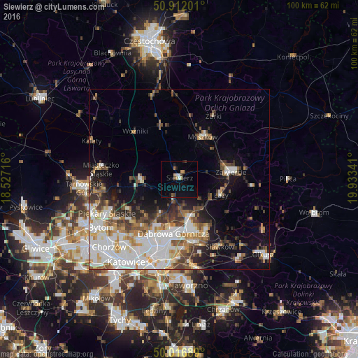
Analysis of Siewierz night lights 2016
Square area 10x10 km:
 0.98%
0.98%90-99
0.7%80-89
1.4%70-79
0.84%60-69
1.12%50-59
0.56%40-49
1.54%30-39
0.42%20-29
0.56%10-19
2.8%0-9
89.08%Square area 50x50 km:
6.25%90-99
5.58%80-89
1.85%70-79
2.16%60-69
2.63%50-59
2.79%40-49
3.05%30-39
2.95%20-29
3.16%10-19
7.02%0-9
62.55%Clear (daylight) street map image can be seen on geolist.org.
Map coordinates:
50° 54' 43.2" North, 18° 31' 37.8" East
50° 27' 59.7" North, 19° 13' 49" East
50° 1' 0.8" North, 19° 56' 0.3" East
Some cities around Siewierz sort by population:
• Dąbrowa Górnicza
14.9 km =9.3 mi,  186°
186°
• Będzin
17.3 km =10.7 mi,  205°
205°
• Zawiercie
13.4 km =8.3 mi,  79°
79°
• Czeladź
20 km =12.4 mi, 212°
• Myszków
13.8 km =8.6 mi,  28°
28°
• Wojkowice
17.8 km =11.1 mi,  230°
230°
• Poręba
8.1 km =5 mi,  72°
72°
• Łazy
12.4 km =7.7 mi,  110°
110°
3085925 (p: 5,417)
Sources (retrieved 2019-11-25):
» Earth at Night: Flat Maps 2012, 2016