Klucze night lights from space
Night Light of Klucze (Lesser Poland) from space (Poland) Src. Average luminocity for 10x10km area is 8.619% and for 50x50km: 13.8771%.
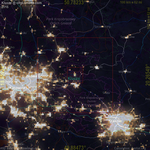
Analysis of Klucze night lights 2016
Square area 10x10 km:
 0%
0%90-99
0%80-89
0.7%70-79
0.98%60-69
1.12%50-59
1.12%40-49
1.4%30-39
3.08%20-29
0.84%10-19
12.04%0-9
78.71%Square area 50x50 km:
1.68%90-99
2.16%80-89
0.96%70-79
1.28%60-69
2.06%50-59
2.36%40-49
2.8%30-39
2.9%20-29
3.53%10-19
9.88%0-9
70.38%Clear (daylight) street map image can be seen on geolist.org.
Map coordinates:
50° 46' 56.4" North, 18° 51' 33.3" East
50° 20' 8.3" North, 19° 33' 44.5" East
49° 53' 5" North, 20° 15' 55.8" East
Some cities around Klucze sort by population:
• Zawiercie
19.8 km =12.3 mi,  328°
328°
• Olkusz
6 km =3.7 mi,  178°
178°
• Trzebinia
20.7 km =12.9 mi,  198°
198°
• Bukowno
10.7 km =6.6 mi,  222°
222°
• Krzeszowice
22 km =13.7 mi,  166°
166°
• Wolbrom
14.7 km =9.1 mi,  70°
70°
• Łazy
15.7 km =9.8 mi,  310°
310°
• Sławków
12.9 km =8 mi,  251°
251°
3096002 (p: 5,926)
Sources (retrieved 2019-11-25):
» Earth at Night: Flat Maps 2012, 2016