Koronowo night lights from space
Night Light of Koronowo (Kujawsko-Pomorskie) from space (Poland) Src. Average luminocity for 10x10km area is 4.2449% and for 50x50km: 6.4516%.
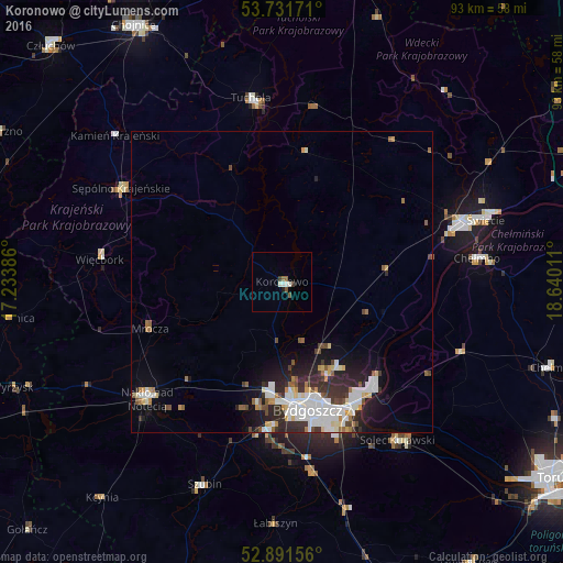
Analysis of Koronowo night lights 2016
Square area 10x10 km:
 0.76%
0.76%90-99
1.26%80-89
0%70-79
0%60-69
0.51%50-59
1.14%40-49
0.51%30-39
0.88%20-29
0%10-19
0.51%0-9
94.44%Square area 50x50 km:
1.55%90-99
1.49%80-89
0.52%70-79
0.54%60-69
0.49%50-59
0.61%40-49
0.65%30-39
0.94%20-29
1.98%10-19
2.98%0-9
88.26%Clear (daylight) street map image can be seen on geolist.org.
Map coordinates:
53° 43' 54.2" North, 17° 14' 1.9" East
53° 18' 49.3" North, 17° 56' 13.1" East
52° 53' 29.6" North, 18° 38' 24.4" East
Some cities around Koronowo sort by population:
• Bydgoszcz
21.7 km =13.5 mi,  167°
167°
• Fordon
24.1 km =15 mi,  139°
139°
• Nakło nad Notecią
29.4 km =18.3 mi,  229°
229°
• Solec Kujawski
32 km =19.9 mi, 143°
• Tuchola
30.9 km =19.2 mi,  350°
350°
• Sępólno Krajeńskie
31 km =19.3 mi,  299°
299°
• Białe Błota
24.3 km =15.1 mi,  183°
183°
• Więcbork
30 km =18.6 mi,  278°
278°
3095192 (p: 10,965)
Sources (retrieved 2019-11-25):
» Earth at Night: Flat Maps 2012, 2016