Solec Kujawski night lights from space
Night Light of Solec Kujawski (Kujawsko-Pomorskie) from space (Poland) Src. Average luminocity for 10x10km area is 9.9365% and for 50x50km: 8.6414%.
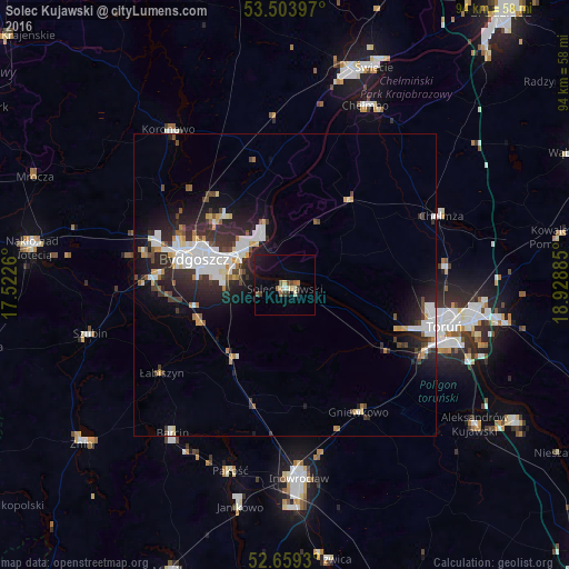
Analysis of Solec Kujawski night lights 2016
Square area 10x10 km:
 0.4%
0.4%90-99
1.72%80-89
1.06%70-79
0.13%60-69
1.72%50-59
1.72%40-49
1.19%30-39
2.12%20-29
0.79%10-19
6.88%0-9
82.28%Square area 50x50 km:
1.88%90-99
1.8%80-89
0.66%70-79
0.69%60-69
0.61%50-59
0.59%40-49
1.07%30-39
1.53%20-29
3.18%10-19
5.52%0-9
82.48%Clear (daylight) street map image can be seen on geolist.org.
Map coordinates:
53° 30' 14.3" North, 17° 31' 21.4" East
53° 5' 1.4" North, 18° 13' 32.6" East
52° 39' 33.5" North, 18° 55' 43.9" East
Some cities around Solec Kujawski sort by population:
• Bydgoszcz
15.2 km =9.4 mi,  286°
286°
• Toruń
26.1 km =16.2 mi,  107°
107°
• Inowrocław
31.8 km =19.8 mi,  175°
175°
• Fordon
8.1 km =5 mi,  332°
332°
• Chełmża
27.7 km =17.2 mi,  66°
66°
• Barcin
30.6 km =19 mi,  217°
217°
• Gniewkowo
24.3 km =15.1 mi,  149°
149°
• Białe Błota
20.7 km =12.9 mi,  273°
273°
3085172 (p: 15,125)
Sources (retrieved 2019-11-25):
» Earth at Night: Flat Maps 2012, 2016