Korczyna night lights from space
Night Light of Korczyna (Subcarpathia) from space (Poland) Src. Average luminocity for 10x10km area is 18.3275% and for 50x50km: 2.3468%.
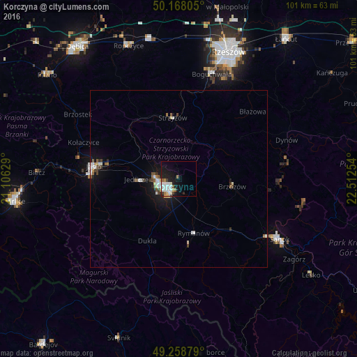
Analysis of Korczyna night lights 2016
Square area 10x10 km:
 4.68%
4.68%90-99
4.68%80-89
2.01%70-79
1.2%60-69
1.07%50-59
1.6%40-49
1.34%30-39
0.67%20-29
2.67%10-19
16.44%0-9
63.64%Square area 50x50 km:
0.42%90-99
0.46%80-89
0.25%70-79
0.16%60-69
0.12%50-59
0.28%40-49
0.41%30-39
0.2%20-29
0.24%10-19
2.14%0-9
95.33%Clear (daylight) street map image can be seen on geolist.org.
Map coordinates:
50° 10' 5" North, 21° 6' 22.6" East
49° 42' 56" North, 21° 48' 33.9" East
49° 15' 31.6" North, 22° 30' 45.1" East
Some cities around Korczyna sort by population:
• Krosno
4.1 km =2.5 mi,  223°
223°
• Sanok
33.6 km =20.9 mi,  121°
121°
• Jasło
24.4 km =15.2 mi,  277°
277°
• Strzyżów
17.3 km =10.7 mi,  356°
356°
• Brzozów
15.3 km =9.5 mi,  98°
98°
• Dynów
32.4 km =20.1 mi,  70°
70°
• Boguchwała
31.5 km =19.6 mi,  18°
18°
• Jedlicze
11.5 km =7.1 mi,  271°
271°
768136 (p: 6,100)
Sources (retrieved 2019-11-25):
» Earth at Night: Flat Maps 2012, 2016