Karlino night lights from space
Night Light of Karlino (West Pomerania) from space (Poland) Src. Average luminocity for 10x10km area is 1.8687% and for 50x50km: 3.2086%.
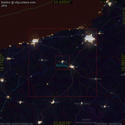
Analysis of Karlino night lights 2016
Square area 10x10 km:
 0.25%
0.25%90-99
0.25%80-89
0%70-79
1.01%60-69
0%50-59
0%40-49
0.25%30-39
0.25%20-29
0%10-19
0%0-9
97.98%Square area 50x50 km:
0.76%90-99
0.68%80-89
0.13%70-79
0.28%60-69
0.14%50-59
0.24%40-49
0.46%30-39
0.31%20-29
0.67%10-19
2.87%0-9
93.46%Clear (daylight) street map image can be seen on geolist.org.
Map coordinates:
54° 26' 45.7" North, 15° 10' 27.4" East
54° 2' 6.5" North, 15° 52' 38.6" East
53° 37' 12.6" North, 16° 34' 49.9" East
Some cities around Karlino sort by population:
• Koszalin
26.1 km =16.2 mi,  47°
47°
• Kołobrzeg
24.7 km =15.3 mi,  309°
309°
• Białogard
7.8 km =4.8 mi,  113°
113°
• Gryfice
46.2 km =28.7 mi,  253°
253°
• Świdwin
29.7 km =18.5 mi,  192°
192°
• Trzebiatów
40.1 km =24.9 mi,  274°
274°
• Połczyn-Zdrój
33.3 km =20.7 mi,  154°
154°
• Sianów
34.3 km =21.3 mi, 51°
3096630 (p: 5,832)
Sources (retrieved 2019-11-25):
» Earth at Night: Flat Maps 2012, 2016