Tajao night lights from space
Night Light of Tajao (Central Visayas) from space (Philippines) Src. Average luminocity for 10x10km area is 3.9504% and for 50x50km: 4.742%.
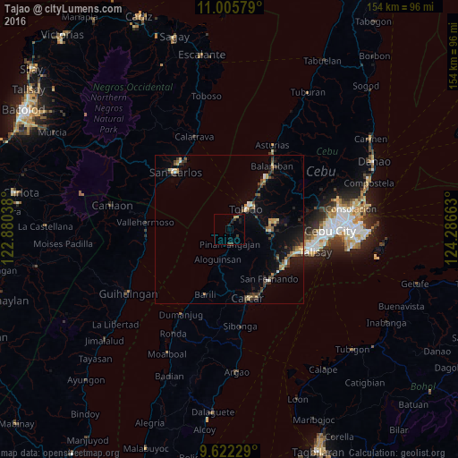
Analysis of Tajao night lights 2016
Square area 10x10 km:
 0%
0%90-99
0%80-89
0.41%70-79
1.24%60-69
0%50-59
0%40-49
1.03%30-39
1.86%20-29
2.27%10-19
1.86%0-9
91.32%Square area 50x50 km:
0.29%90-99
0.31%80-89
0.71%70-79
0.58%60-69
0.62%50-59
0.42%40-49
1.06%30-39
0.99%20-29
1.22%10-19
2.64%0-9
91.14%Clear (daylight) street map image can be seen on geolist.org.
Map coordinates:
11° 0' 20.8" North, 122° 52' 49.4" East
10° 18' 53.3" North, 123° 35' 0.6" East
9° 37' 20.2" North, 124° 17' 11.9" East
Some cities around Tajao sort by population:
• Toledo
9.2 km =5.7 mi,  40°
40°
• San Fernando
21.7 km =13.5 mi,  141°
141°
• Pinamungahan
4.9 km =3 mi,  179°
179°
• Buanoy
21.2 km =13.2 mi, 36°
• Tutay
7.6 km =4.7 mi, 182°
• Bonbon
10.4 km =6.5 mi,  195°
195°
• Langtad
21.9 km =13.6 mi,  131°
131°
• Valencia
20.1 km =12.5 mi,  170°
170°
1684210 (p: 5,394)
Sources (retrieved 2019-11-25):
» Earth at Night: Flat Maps 2012, 2016