Tutay night lights from space
Night Light of Tutay (Central Visayas) from space (Philippines) Src. Average luminocity for 10x10km area is 1.1074% and for 50x50km: 3.8948%.
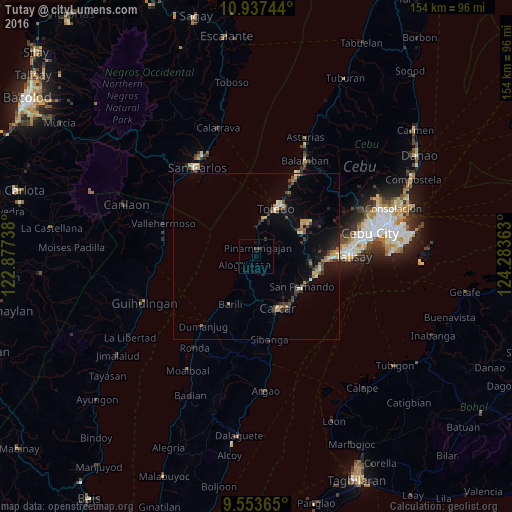
Analysis of Tutay night lights 2016
Square area 10x10 km:
 0%
0%90-99
0%80-89
0%70-79
0%60-69
0%50-59
0%40-49
1.24%30-39
0.83%20-29
0%10-19
0.41%0-9
97.52%Square area 50x50 km:
0.23%90-99
0.24%80-89
0.48%70-79
0.49%60-69
0.6%50-59
0.31%40-49
0.95%30-39
0.72%20-29
1.07%10-19
2.46%0-9
92.46%Clear (daylight) street map image can be seen on geolist.org.
Map coordinates:
10° 56' 14.8" North, 122° 52' 38.6" East
10° 14' 46.7" North, 123° 34' 49.8" East
9° 33' 13.1" North, 124° 17' 1.1" East
Some cities around Tutay sort by population:
• Toledo
15.9 km =9.9 mi,  23°
23°
• Pinamungahan
2.7 km =1.7 mi,  7°
7°
• Guadalupe
14.7 km =9.1 mi,  168°
168°
• Barili
16.5 km =10.3 mi,  207°
207°
• Can-asujan
15.4 km =9.6 mi,  146°
146°
• Bonbon
3.5 km =2.2 mi,  226°
226°
• Tajao
7.6 km =4.7 mi,  2°
2°
• Valencia
12.8 km =8 mi,  164°
164°
1680570 (p: 7,808)
Sources (retrieved 2019-11-25):
» Earth at Night: Flat Maps 2012, 2016