Santo Rosario night lights from space
Night Light of Santo Rosario (Central Luzon) from space (Philippines) Src. Average luminocity for 10x10km area is 3.1602% and for 50x50km: 3.6043%.
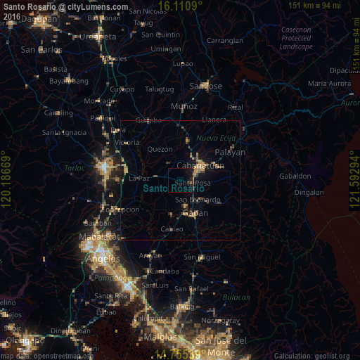
Analysis of Santo Rosario night lights 2016
Square area 10x10 km:
 0%
0%90-99
0%80-89
0%70-79
0%60-69
0%50-59
0.22%40-49
0.65%30-39
0.87%20-29
1.3%10-19
4.98%0-9
91.99%Square area 50x50 km:
0%90-99
0.03%80-89
0.26%70-79
0.94%60-69
0.71%50-59
0.37%40-49
1.06%30-39
0.76%20-29
0.78%10-19
2.58%0-9
92.52%Clear (daylight) street map image can be seen on geolist.org.
Map coordinates:
16° 6' 39.2" North, 120° 11' 12.1" East
15° 26' 3.3" North, 120° 53' 23.3" East
14° 45' 19.4" North, 121° 35' 34.6" East
Some cities around Santo Rosario sort by population:
• Cabanatuan City
10 km =6.2 mi,  55°
55°
• San Leonardo
11.2 km =7 mi,  134°
134°
• Aliaga
8.9 km =5.5 mi,  325°
325°
• San Francisco
10.2 km =6.3 mi,  211°
211°
• Santa Rosa
5.3 km =3.3 mi,  102°
102°
• Rajal Norte
3.1 km =1.9 mi,  291°
291°
• Bibiclat
10.2 km =6.3 mi,  343°
343°
• Santa Barbara
11.4 km =7.1 mi,  241°
241°
1687570 (p: 6,005)
Sources (retrieved 2019-11-25):
» Earth at Night: Flat Maps 2012, 2016