Santa Rosa night lights from space
Night Light of Santa Rosa (Central Luzon) from space (Philippines) Src. Average luminocity for 10x10km area is 12.1667% and for 50x50km: 2.9919%.
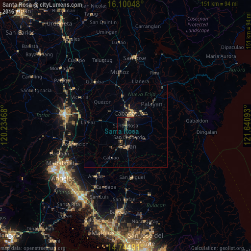
Analysis of Santa Rosa night lights 2016
Square area 10x10 km:
 0%
0%90-99
0%80-89
0.87%70-79
2.38%60-69
1.95%50-59
2.38%40-49
4.33%30-39
1.73%20-29
2.38%10-19
11.47%0-9
72.51%Square area 50x50 km:
0%90-99
0.03%80-89
0.19%70-79
0.79%60-69
0.54%50-59
0.27%40-49
0.99%30-39
0.72%20-29
0.68%10-19
2.17%0-9
93.62%Clear (daylight) street map image can be seen on geolist.org.
Map coordinates:
16° 6' 1.7" North, 120° 14' 4.8" East
15° 25' 25.7" North, 120° 56' 16.1" East
14° 44' 41.7" North, 121° 38' 27.3" East
Some cities around Santa Rosa sort by population:
• Cabanatuan City
7.6 km =4.7 mi,  24°
24°
• Jaen
10.9 km =6.8 mi,  190°
190°
• San Leonardo
7.3 km =4.5 mi,  157°
157°
• Peñaranda
10.7 km =6.6 mi,  138°
138°
• San Francisco
12.9 km =8 mi,  234°
234°
• Rajal Norte
8.4 km =5.2 mi,  286°
286°
• Nieves
10.7 km =6.6 mi,  173°
173°
• Santo Rosario
5.3 km =3.3 mi,  282°
282°
1687888 (p: 11,683)
Sources (retrieved 2019-11-25):
» Earth at Night: Flat Maps 2012, 2016