San Francisco night lights from space
Night Light of San Francisco (Central Luzon) from space (Philippines) Src. Average luminocity for 10x10km area is 0.3961% and for 50x50km: 6.5624%.
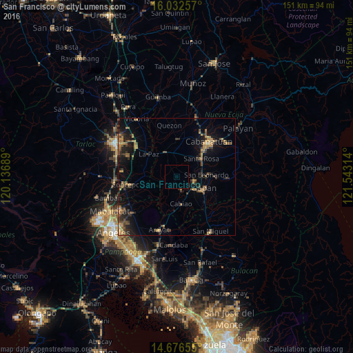
Analysis of San Francisco night lights 2016
Square area 10x10 km:
 0%
0%90-99
0%80-89
0%70-79
0%60-69
0%50-59
0%40-49
0%30-39
0%20-29
0%10-19
0%0-9
100%Square area 50x50 km:
0.02%90-99
0.05%80-89
0.48%70-79
1.6%60-69
1.49%50-59
0.91%40-49
1.65%30-39
1.4%20-29
2.12%10-19
5.39%0-9
84.89%Clear (daylight) street map image can be seen on geolist.org.
Map coordinates:
16° 1' 57.3" North, 120° 8' 12.8" East
15° 21' 20.4" North, 120° 50' 24" East
14° 40' 35.6" North, 121° 32' 35.3" East
Some cities around San Francisco sort by population:
• Jaen
9.1 km =5.7 mi,  110°
110°
• Papaya
4 km =2.5 mi,  186°
186°
• San Antonio
5.8 km =3.6 mi,  162°
162°
• Rajal Norte
10.2 km =6.3 mi,  13°
13°
• Santo Cristo
8.5 km =5.3 mi,  140°
140°
• Santa Barbara
5.7 km =3.5 mi,  304°
304°
• San Mariano
5.5 km =3.4 mi, 135°
• Entablado
8.1 km =5 mi, 162°
1689973 (p: 19,570)
Sources (retrieved 2019-11-25):
» Earth at Night: Flat Maps 2012, 2016