San Jacinto night lights from space
Night Light of San Jacinto (Ilocos) from space (Philippines) Src. Average luminocity for 10x10km area is 12.7707% and for 50x50km: 5.7092%.
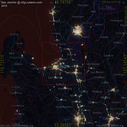
Analysis of San Jacinto night lights 2016
Square area 10x10 km:
 0%
0%90-99
0%80-89
0.62%70-79
2.27%60-69
0.83%50-59
1.86%40-49
5.37%30-39
4.96%20-29
2.89%10-19
14.05%0-9
67.15%Square area 50x50 km:
0.07%90-99
0.06%80-89
0.47%70-79
1.29%60-69
1.09%50-59
0.75%40-49
1.57%30-39
1.66%20-29
1.26%10-19
3.47%0-9
88.3%Clear (daylight) street map image can be seen on geolist.org.
Map coordinates:
16° 44' 49.5" North, 119° 44' 6.6" East
16° 4' 21.4" North, 120° 26' 17.9" East
15° 23' 45" North, 121° 8' 29.1" East
Some cities around San Jacinto sort by population:
• Mangaldan
3.8 km =2.4 mi,  265°
265°
• Manaoag
6 km =3.7 mi,  122°
122°
• Calasiao
10.8 km =6.7 mi,  230°
230°
• Santa Barbara
8.9 km =5.5 mi,  205°
205°
• Nibaliw Central
7.2 km =4.5 mi,  328°
328°
• Mapandan
5.6 km =3.5 mi,  161°
161°
• Nilombot
4.7 km =2.9 mi,  181°
181°
• Minien East
11.6 km =7.2 mi, 156°
1689603 (p: 10,529)
Sources (retrieved 2019-11-25):
» Earth at Night: Flat Maps 2012, 2016