Mapandan night lights from space
Night Light of Mapandan (Ilocos) from space (Philippines) Src. Average luminocity for 10x10km area is 10.3223% and for 50x50km: 5.925%.
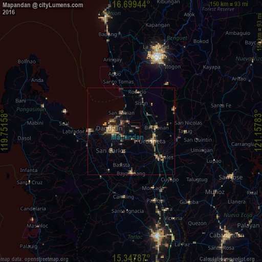
Analysis of Mapandan night lights 2016
Square area 10x10 km:
 0%
0%90-99
0%80-89
0%70-79
1.65%60-69
1.65%50-59
1.65%40-49
3.51%30-39
3.72%20-29
3.1%10-19
7.44%0-9
77.27%Square area 50x50 km:
0.07%90-99
0.06%80-89
0.53%70-79
1.35%60-69
1.12%50-59
0.79%40-49
1.65%30-39
1.67%20-29
1.36%10-19
3.55%0-9
87.86%Clear (daylight) street map image can be seen on geolist.org.
Map coordinates:
16° 41' 58" North, 119° 45' 5.7" East
16° 1' 29.3" North, 120° 27' 16.9" East
15° 20' 52.3" North, 121° 9' 28.2" East
Some cities around Mapandan sort by population:
• Mangaldan
7.5 km =4.7 mi,  312°
312°
• Manaoag
4 km =2.5 mi,  57°
57°
• Santa Barbara
6.2 km =3.9 mi,  244°
244°
• San Jacinto
5.6 km =3.5 mi,  341°
341°
• Nilombot
2 km =1.2 mi,  288°
288°
• Loqueb Este
8.9 km =5.5 mi,  185°
185°
• Minien East
6 km =3.7 mi,  151°
151°
• Catablan
7 km =4.3 mi,  141°
141°
1701290 (p: 11,165)
Sources (retrieved 2019-11-25):
» Earth at Night: Flat Maps 2012, 2016