Nibaliw Central night lights from space
Night Light of Nibaliw Central (Ilocos) from space (Philippines) Src. Average luminocity for 10x10km area is 8.907% and for 50x50km: 5.2942%.
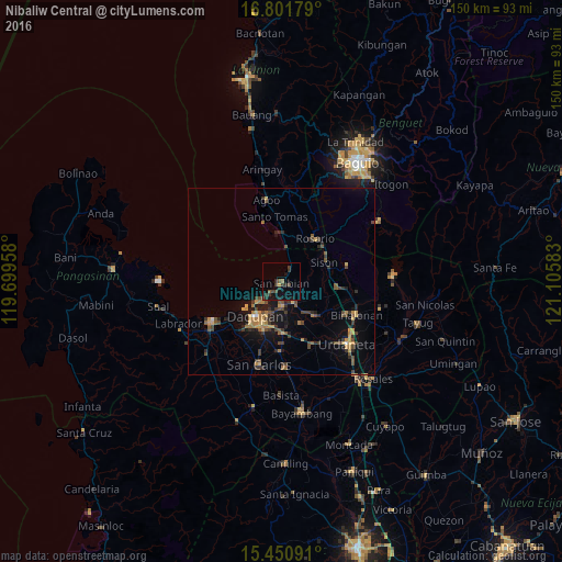
Analysis of Nibaliw Central night lights 2016
Square area 10x10 km:
 0%
0%90-99
0%80-89
0.21%70-79
0.62%60-69
0.83%50-59
0.83%40-49
4.13%30-39
4.75%20-29
3.51%10-19
7.02%0-9
78.1%Square area 50x50 km:
0.07%90-99
0.06%80-89
0.43%70-79
1.14%60-69
0.93%50-59
0.71%40-49
1.55%30-39
1.41%20-29
1.19%10-19
3.49%0-9
89.01%Clear (daylight) street map image can be seen on geolist.org.
Map coordinates:
16° 48' 6.4" North, 119° 41' 58.5" East
16° 7' 39" North, 120° 24' 9.7" East
15° 27' 3.3" North, 121° 6' 21" East
Some cities around Nibaliw Central sort by population:
• Dagupan
12 km =7.5 mi,  218°
218°
• Mangaldan
6.4 km =4 mi,  180°
180°
• Manaoag
12.9 km =8 mi,  136°
136°
• Calasiao
13.7 km =8.5 mi,  199°
199°
• Mapandan
12.7 km =7.9 mi,  154°
154°
• San Jacinto
7.2 km =4.5 mi, 148°
• Sison
13.1 km =8.1 mi,  66°
66°
• Nilombot
11.4 km =7.1 mi,  161°
161°
1697707 (p: 13,631)
Sources (retrieved 2019-11-25):
» Earth at Night: Flat Maps 2012, 2016