Mexico night lights from space
Night Light of Mexico (Central Luzon) from space (Philippines) Src. Average luminocity for 10x10km area is 39.5289% and for 50x50km: 19.1853%.
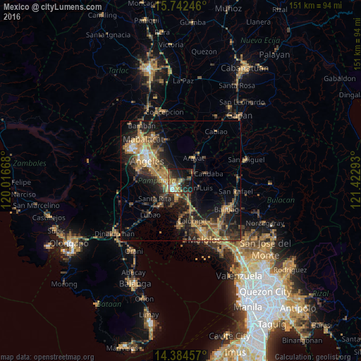

Analysis of Mexico night lights 2016
Square area 10x10 km:
 3.72%
3.72%90-99
5.37%80-89
2.69%70-79
9.5%60-69
8.06%50-59
4.55%40-49
6.61%30-39
7.02%20-29
16.94%10-19
26.03%0-9
9.5%Square area 50x50 km:
0.85%90-99
1.15%80-89
1.53%70-79
4.99%60-69
5.06%50-59
2.17%40-49
4.1%30-39
4.23%20-29
6.87%10-19
12.96%0-9
56.08%Clear (daylight) street map image can be seen on geolist.org.
Map coordinates:
15° 44' 32.9" North, 120° 1' 0" East
15° 3' 52.6" North, 120° 43' 11.3" East
14° 23' 4.5" North, 121° 25' 22.5" East
Some cities around Mexico sort by population:
• San Fernando
5.1 km =3.2 mi,  228°
228°
• Bulaon
6.4 km =4 mi,  288°
288°
• Santa Ana
6.1 km =3.8 mi,  55°
55°
• Del Pilar
3.9 km =2.4 mi,  214°
214°
• San Luis
7.8 km =4.8 mi,  110°
110°
• San Simon
9.8 km =6.1 mi,  137°
137°
• San Jose
7.7 km =4.8 mi,  117°
117°
• Santo Domingo
8.5 km =5.3 mi,  162°
162°
1699805 (p: 43,694)
Sources (retrieved 2019-11-25):
» Earth at Night: Flat Maps 2012, 2016