San Jose night lights from space
Night Light of San Jose (Central Luzon) from space (Philippines) Src. Average luminocity for 10x10km area is 11.8946% and for 50x50km: 19.6703%.
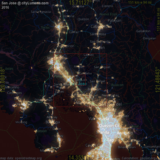
Analysis of San Jose night lights 2016
Square area 10x10 km:
 0%
0%90-99
0%80-89
0%70-79
0%60-69
4.13%50-59
1.24%40-49
3.51%30-39
3.51%20-29
4.75%10-19
19.21%0-9
63.64%Square area 50x50 km:
0.69%90-99
0.95%80-89
1.51%70-79
5.24%60-69
5.8%50-59
2.59%40-49
4.6%30-39
4.57%20-29
6.67%10-19
11.3%0-9
56.06%Clear (daylight) street map image can be seen on geolist.org.
Map coordinates:
15° 42' 40.6" North, 120° 4' 48.6" East
15° 1' 59.9" North, 120° 46' 59.9" East
14° 21' 11.4" North, 121° 29' 11.1" East
Some cities around San Jose sort by population:
• Apalit
9 km =5.6 mi,  189°
189°
• Candaba
8.3 km =5.2 mi,  33°
33°
• Santa Ana
7.1 km =4.4 mi,  345°
345°
• Mexico
7.7 km =4.8 mi,  297°
297°
• San Luis
0.9 km =0.6 mi,  35°
35°
• San Simon
3.8 km =2.4 mi,  184°
184°
• San Isidro
4.2 km =2.6 mi,  108°
108°
• Santo Domingo
6.3 km =3.9 mi,  222°
222°
1689448 (p: 7,461)
Sources (retrieved 2019-11-25):
» Earth at Night: Flat Maps 2012, 2016