Catablan night lights from space
Night Light of Catablan (Ilocos) from space (Philippines) Src. Average luminocity for 10x10km area is 4.5826% and for 50x50km: 5.7044%.
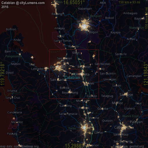
Analysis of Catablan night lights 2016
Square area 10x10 km:
 0%
0%90-99
0%80-89
0%70-79
0.83%60-69
0%50-59
0.83%40-49
2.07%30-39
1.03%20-29
2.07%10-19
0.21%0-9
92.98%Square area 50x50 km:
0.06%90-99
0.04%80-89
0.53%70-79
1.22%60-69
1.22%50-59
0.65%40-49
1.52%30-39
1.69%20-29
1.25%10-19
3.56%0-9
88.27%Clear (daylight) street map image can be seen on geolist.org.
Map coordinates:
16° 39' 1.8" North, 119° 47' 31.8" East
15° 58' 32.5" North, 120° 29' 43.1" East
15° 17' 55" North, 121° 11' 54.3" East
Some cities around Catablan sort by population:
• Urdaneta
8.1 km =5 mi,  89°
89°
• Manaoag
7.6 km =4.7 mi,  352°
352°
• Santa Barbara
10.3 km =6.4 mi,  285°
285°
• Mapandan
7 km =4.3 mi,  321°
321°
• Bulog
10.2 km =6.3 mi,  260°
260°
• Nilombot
8.7 km =5.4 mi,  314°
314°
• Loqueb Este
6.3 km =3.9 mi,  236°
236°
• Minien East
1.5 km =0.9 mi,  276°
276°
1718033 (p: 5,091)
Sources (retrieved 2019-11-25):
» Earth at Night: Flat Maps 2012, 2016