Maguyam night lights from space
Night Light of Maguyam (Calabarzon) from space (Philippines) Src. Average luminocity for 10x10km area is 60.7165% and for 50x50km: 35.2847%.
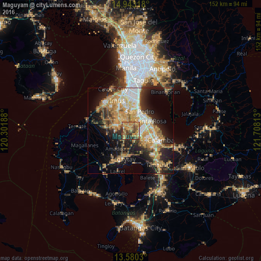
Analysis of Maguyam night lights 2016
Square area 10x10 km:
 1.3%
1.3%90-99
1.3%80-89
8.66%70-79
28.35%60-69
20.56%50-59
10.61%40-49
13.85%30-39
7.58%20-29
7.79%10-19
0%0-9
0%Square area 50x50 km:
4.09%90-99
5.64%80-89
4.36%70-79
10.18%60-69
6.88%50-59
3.15%40-49
4.47%30-39
4.36%20-29
7.71%10-19
14.93%0-9
34.24%Clear (daylight) street map image can be seen on geolist.org.
Map coordinates:
14° 56' 35.4" North, 120° 18' 6.8" East
14° 15' 46" North, 121° 0' 18" East
13° 34' 49.1" North, 121° 42' 29.3" East
Some cities around Maguyam sort by population:
• Dasmariñas
10.4 km =6.5 mi,  315°
315°
• San Pedro
11.7 km =7.3 mi,  22°
22°
• Silang
6.4 km =4 mi,  214°
214°
• Pulong Santa Cruz
7.8 km =4.8 mi,  81°
81°
• Carmona
8 km =5 mi,  45°
45°
• Bulihan
2 km =1.2 mi,  327°
327°
• Manggahan
11.6 km =7.2 mi,  286°
286°
• Balite Segundo
9.4 km =5.8 mi,  200°
200°
1703667 (p: 5,437)
Sources (retrieved 2019-11-25):
» Earth at Night: Flat Maps 2012, 2016