Balite Segundo night lights from space
Night Light of Balite Segundo (Calabarzon) from space (Philippines) Src. Average luminocity for 10x10km area is 27.974% and for 50x50km: 29.34%.
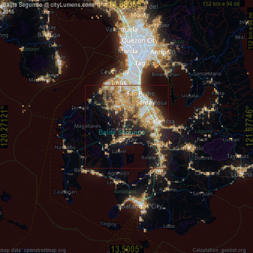
Analysis of Balite Segundo night lights 2016
Square area 10x10 km:
 0%
0%90-99
0%80-89
0.65%70-79
5.84%60-69
2.81%50-59
5.63%40-49
8.87%30-39
8.23%20-29
14.94%10-19
52.38%0-9
0.65%Square area 50x50 km:
2.4%90-99
3.77%80-89
3.45%70-79
9.68%60-69
6.31%50-59
2.9%40-49
4.37%30-39
3.88%20-29
6.84%10-19
12.41%0-9
43.99%Clear (daylight) street map image can be seen on geolist.org.
Map coordinates:
14° 51' 49.9" North, 120° 16' 16.4" East
14° 10' 59.5" North, 120° 58' 27.6" East
13° 30' 1.8" North, 121° 40' 38.9" East
Some cities around Balite Segundo sort by population:
• Silang
3.6 km =2.2 mi,  354°
354°
• Tagaytay
10.7 km =6.6 mi,  204°
204°
• Patuto
7.4 km =4.6 mi,  186°
186°
• Indang
10.6 km =6.6 mi,  277°
277°
• Mendez-Nuñez
9.6 km =6 mi,  230°
230°
• Amadeo
5.6 km =3.5 mi,  255°
255°
• Malabag
3.3 km =2.1 mi, 197°
• Maguyam
9.4 km =5.8 mi,  20°
20°
1728002 (p: 7,495)
Sources (retrieved 2019-11-25):
» Earth at Night: Flat Maps 2012, 2016