Lloren night lights from space
Night Light of Lloren (Ilocos) from space (Philippines) Src. Average luminocity for 10x10km area is 0.0331% and for 50x50km: 4.636%.
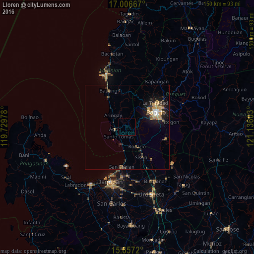
Analysis of Lloren night lights 2016
Square area 10x10 km:
 0%
0%90-99
0%80-89
0%70-79
0%60-69
0%50-59
0%40-49
0%30-39
0%20-29
0%10-19
0%0-9
100%Square area 50x50 km:
0.35%90-99
0.37%80-89
0.72%70-79
1.36%60-69
0.45%50-59
0.41%40-49
0.83%30-39
0.65%20-29
1.31%10-19
3.27%0-9
90.27%Clear (daylight) street map image can be seen on geolist.org.
Map coordinates:
17° 0' 24" North, 119° 43' 47.2" East
16° 19' 59.2" North, 120° 25' 58.4" East
15° 39' 25.9" North, 121° 8' 9.7" East
Some cities around Lloren sort by population:
• Baguio
19.4 km =12.1 mi,  61°
61°
• La Trinidad
21.3 km =13.2 mi,  50°
50°
• Aringay
10.8 km =6.7 mi,  308°
308°
• Nibaliw Central
23.1 km =14.4 mi,  188°
188°
• Payocpoc Sur
21.1 km =13.1 mi,  328°
328°
• Sison
19.8 km =12.3 mi,  153°
153°
• Tuding
23.9 km =14.9 mi,  68°
68°
• Subusub
13.5 km =8.4 mi, 150°
1688789 (p: 5,800)
Sources (retrieved 2019-11-25):
» Earth at Night: Flat Maps 2012, 2016