Jaclupan night lights from space
Night Light of Jaclupan (Central Visayas) from space (Philippines) Src. Average luminocity for 10x10km area is 36.3079% and for 50x50km: 15.9811%.
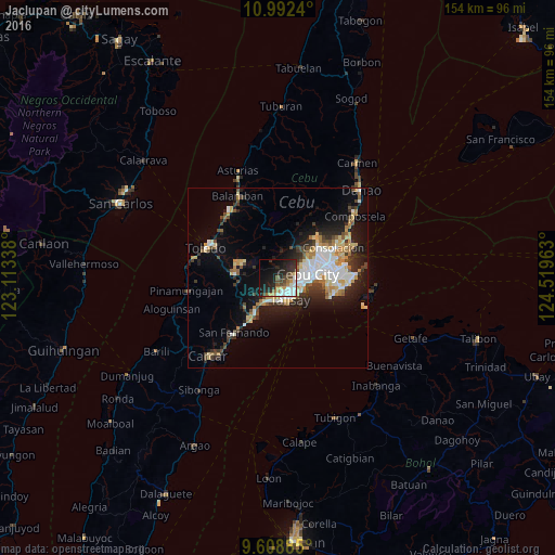
Analysis of Jaclupan night lights 2016
Square area 10x10 km:
 7.85%
7.85%90-99
7.02%80-89
1.65%70-79
4.55%60-69
3.1%50-59
3.51%40-49
7.02%30-39
4.13%20-29
19.01%10-19
22.73%0-9
19.42%Square area 50x50 km:
2.97%90-99
2.91%80-89
1.97%70-79
1.7%60-69
2.18%50-59
1.12%40-49
2.21%30-39
2.19%20-29
4.46%10-19
8.32%0-9
69.97%Clear (daylight) street map image can be seen on geolist.org.
Map coordinates:
10° 59' 32.6" North, 123° 6' 48.2" East
10° 18' 5" North, 123° 48' 59.4" East
9° 36' 31.9" North, 124° 31' 10.7" East
Some cities around Jaclupan sort by population:
• Cebu City
8.3 km =5.2 mi,  78°
78°
• Lapu-Lapu City
14.6 km =9.1 mi,  86°
86°
• Mandaue City
11.8 km =7.3 mi, 77°
• Talisay
7.3 km =4.5 mi,  150°
150°
• Minglanilla
6.6 km =4.1 mi,  199°
199°
• Naga
12.1 km =7.5 mi,  211°
211°
• Apas
10.4 km =6.5 mi,  65°
65°
• Inayagan
9 km =5.6 mi,  215°
215°
1710395 (p: 9,652)
Sources (retrieved 2019-11-25):
» Earth at Night: Flat Maps 2012, 2016